1990s Maps of Jefferson County, Alabama
Explore 7 historic maps of Jefferson County from the 1990s. These maps offer a rare glimpse into what life looked like during the 1990s — showing old roads, neighborhoods, homes, and landmarks that have changed or disappeared over time.
Whether you're researching your family's past, planning a metal detecting trip, or studying how Jefferson County's landscape evolved across the 1990s, these high-resolution maps are a powerful tool for exploring the history of this region.
- Focus on a specific era: All maps on this page are from the 1990s, giving you a focused view of this time period.
- See what’s changed: Compare century-old streets, trails, and buildings to today's modern landscape using overlays and satellite layers.
- Research with precision: Use these maps for genealogy, historical research, land use analysis, or educational projects.
- View, download, or print: Maps are fully viewable online in high resolution, and can be downloaded or printed for your own records.
Start exploring Jefferson County's history through authentic maps from the 1990s. This is your window into the past.
Jefferson County, AL maps
(7)- 1993 Map of Adamsville, 1998 Print
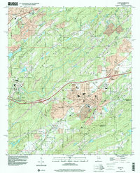
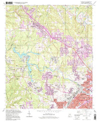 1993 Adamsville1998 Print · USGSJefferson County's industrial and residential corridors are captured here in the 1990s, revealing the lasting footprint of the area's rail and mining history. Genealogists and historians can trace family roots through landmarks like Mulga Mine, Crumley Chapel, and the Union Grove Cem.
 - 1997 Map of Helena, 2001 Print
 1997 Helena2001 Print · USGSThe Shelby County hills in the late nineties show a landscape of rapid growth along the Cababa River corridor. Researchers can trace the development of Helena and Pelham alongside local landmarks like Mars Hill Ch and the Scottrock Quarry.
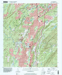
 - 1997 Map of Birmingham North, 2001 Print
 1997 Birmingham North2001 Print · USGSBirmingham and its northern industrial suburbs are captured here in the late nineties, showcasing a dense network of rail yards and neighborhoods. Researchers can trace historic sites like Rickwood Field, Oak Hill Cemetery, and the campus of Birmingham Southern College.
 - 1997 Map of Birmingham South, 2001 Print
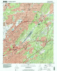
 1997 Birmingham South2001 Print · USGSBirmingham's southern suburbs were expanding rapidly toward the Cahaba River during the late nineties. Genealogists and local historians can trace legacy landmarks like Elmwood Cemetery, the Spaulding Mine, and old neighborhood schools like Hemphill Sch.
 - 1998 Map of Irondale, 2001 Print
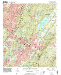
 1998 Irondale2001 Print · USGSThe eastern Birmingham suburbs and the Irondale corridor are shown here in the late nineties as industrial landscapes began to meet sprawling residential growth. Genealogists and local historians can trace family plots in Forest Hill Cemetery or locate landmarks like the Alabama Industrial School for Boys and Gate City.
 - 1998 Map of Cahaba Heights, 2001 Print
 1998 Cahaba Heights2001 Print · USGSGreater Birmingham saw significant suburban growth into the ridges of Shelby County during the late twentieth century. Researchers can trace local lineage and land use through landmarks like Wooten Chapel Cem, the Strip Mine at Acton, and Lake Purdy.
 - 1998 Map of Leeds, 2001 Print
 1998 Leeds2001 Print · USGSLeeds and the Cahaba Valley corridors appear here in the late nineties, showing a landscape shaped by ridge-and-valley terrain and major rail networks. Researchers can trace local history through sites like Moton High Sch, Acmar, and the Oak Mountain Tunnel.
End of results
Showing maps 1-7 of 7
Top cities of Jefferson County
- Birmingham historical maps
- Hoover historical maps
- Vestavia Hills historical maps
- Homewood historical maps
- Trussville historical maps
- Bessemer historical maps
See more
Frequently asked questions
- What are the different types of historical maps available for Jefferson County?
- What is the oldest map of Jefferson County?
- Where can I purchase historical maps of Jefferson County for my home or office?
- Where can I download high-res historical maps of Jefferson County?
- Are there historical topographic maps available for Jefferson County?
- Is there historical aerial imagery available for Jefferson County?
- Where are historical maps of Jefferson County sourced from?