1950s Maps of Lawrence County, Alabama
Explore 14 historic maps of Lawrence County from the 1950s. These maps offer a rare glimpse into what life looked like during the 1950s — showing old roads, neighborhoods, homes, and landmarks that have changed or disappeared over time.
Whether you're researching your family's past, planning a metal detecting trip, or studying how Lawrence County's landscape evolved across the 1950s, these high-resolution maps are a powerful tool for exploring the history of this region.
- Focus on a specific era: All maps on this page are from the 1950s, giving you a focused view of this time period.
- See what’s changed: Compare century-old streets, trails, and buildings to today's modern landscape using overlays and satellite layers.
- Research with precision: Use these maps for genealogy, historical research, land use analysis, or educational projects.
- View, download, or print: Maps are fully viewable online in high resolution, and can be downloaded or printed for your own records.
Start exploring Lawrence County's history through authentic maps from the 1950s. This is your window into the past.
Lawrence County, AL maps
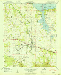
(14)- 1950 Map of Jones Crossroads
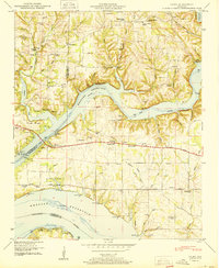
 1950 Jones Crossroads1950 Print · USGSLimestone and Morgan counties meet along the wide waters of the Tennessee River in the post-war era. Genealogists and local historians can trace family plots at Neville Cem or locate community centers like Jones Crossroads and the Pine Ridge School.3 unique versions available
 - 1950 Map of Caddo
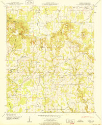 1950 Caddo1950 Print · USGSNorthern Alabama’s uplands are captured here in the early postwar years, showing a landscape of ridge-top churches and creek-bottom farms. Genealogists can locate family names at Thrasher Cem or trace old routes past Morris Chapel and Caddo.2 unique versions available
 - 1950 Map of Trinity
 1950 Trinity1950 Print · USGSMid-century Morgan County is captured here as the Tennessee Valley Authority's influence reshaped the landscape near Trinity and Moulton Heights. Genealogists and historians can trace the locations of family burial grounds like Lile Cem, early schools such as Pleasant Hill School, and natural landmarks like San-Souci Cave.2 unique versions available
 - 1950 Map of Town Creek
 1950 Town Creek1950 Print · USGSNorth Alabama's rail and river corridor comes alive in the late 1940s, centered on the activity at Town Creek. Genealogists and local historians can trace rural family life through landmarks like Winston Quarters, Old Mt Zion Church, and numerous burial grounds including Madding Cem.2 unique versions available
 - 1950 Map of Cairo
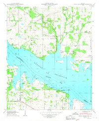
 1950 Cairo1950 Print · USGSThe confluence of the Tennessee and Elk Rivers comes into focus during the late nineteen-forties as the Tennessee Valley Authority managed the developing shoreline. Genealogists can trace family names through Lentzville Cem, Confluence School, and Mt Carmel Church.4 unique versions available
 - 1951 Map of Hatton
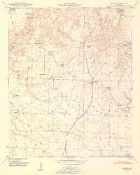 1951 Hatton1951 Print · USGSLawrence County at mid-century reveals a rural landscape defined by the transition from Black Ground Mountain to the Moulton Valley. Genealogists can trace family roots through numerous sites like Beavers Cem, Flat Rock School, and Old Okolona Church.2 unique versions available
 - 1951 Map of Masterson
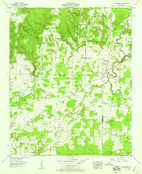
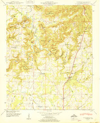 1951 Masterson1951 Print · USGSLawrence County's upland ridges and valley floors are captured here in the mid-century, documenting a landscape of small family settlements and mountain churches. Researchers can locate the Masterson Mill site and trace ancestral roots through sites like the Letson Settlement, Terrytown, and Dossey Cem.
 - 1951 Map of Hillsboro
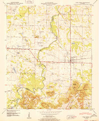
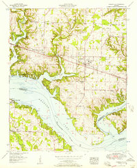
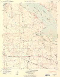 1951 Hillsboro1951 Print · USGSLawrence County life is captured here in the early fifties, showing the area as the local economy balanced riverfront geography with rail access. Genealogists can locate family landmarks like Pointer Quarters and numerous burial grounds including Hillsboro Cem and Canaan Cem.2 unique versions available
 - 1951 Map of Courtland
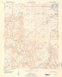
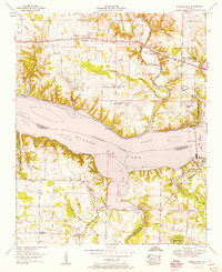
 1951 Courtland1951 Print · USGSLawrence County at the dawn of the fifties reveals a landscape shaped by military aviation and the Tennessee River's reservoir system. Researchers can trace family history through Sherrod Quarters, the Courtland Air Base airfield, and rural landmarks like Little Sam School and Brickhouse Ford.2 unique versions available
 - 1952 Map of Wheeler Dam, 1957 Print
 1952 Wheeler Dam1957 Print · USGSThe Tennessee River corridor transformed in the mid-twentieth century as hydroelectric power and new state parks reshaped the Shoals region. Local historians can trace family roots through Hennigan Cem or explore the early layout of Wheeler Dam Village and Fosters Mill.
 - 1952 Map of Rogersville, 1957 Print
 1952 Rogersville1957 Print · USGSIn the early 1950s, the area around Rogersville, Alabama, was a landscape transformed by the Tennessee Valley Authority. Genealogists and historians can trace family locations through numerous rural burial grounds like McCartney Cem or visit Wheeler Dam Village and Thorntontown.2 unique versions available
 - 1956 Map of Gadsden, 1966 Print
 1956 Gadsden1966 Print · USGSNorth Alabama in the mid-1950s shows a region transformed by river engineering and federal industry. Genealogists and local historians can trace the development of the Tennessee Valley through the growth of Huntsville, the sprawling Redstone Arsenal, and the expansive Guntersville Lake.3 unique versions available
 - 1957 Map of Old Bethel, 1958 Print
 1957 Old Bethel1958 Print · USGSThe rural uplands of Colbert and Franklin Counties come into focus in the late 1950s, showing a landscape of ridge-top farms and deep hollows. Genealogists can trace family footprints through numerous country congregations and schools, including Old Bethel Church, Saints Crossroads, and Rocky Glen School.3 unique versions available
 - 1958 Map of Gadsden
 1958 Gadsden1958 Print · USGSNorth Alabama comes alive in the late 1950s as the Tennessee Valley Authority’s massive river projects and the rise of the space industry reshaped the landscape. Researchers can trace the mid-century footprints of Huntsville, Redstone Arsenal, and the riverside rail networks of the Southern railroad.
End of results
Showing maps 1-14 of 14
Top cities of Lawrence County
- Moulton historical maps
- Town Creek historical maps
- Courtland historical maps
- North Courtland historical maps
- Hillsboro historical maps
- Hatton historical maps
Frequently asked questions
- What are the different types of historical maps available for Lawrence County?
- What is the oldest map of Lawrence County?
- Where can I purchase historical maps of Lawrence County for my home or office?
- Where can I download high-res historical maps of Lawrence County?
- Are there historical topographic maps available for Lawrence County?
- Is there historical aerial imagery available for Lawrence County?
- Where are historical maps of Lawrence County sourced from?