1970s Maps of Lawrence County, Alabama
Explore 6 historic maps of Lawrence County from the 1970s. These maps offer a rare glimpse into what life looked like during the 1970s — showing old roads, neighborhoods, homes, and landmarks that have changed or disappeared over time.
Whether you're researching your family's past, planning a metal detecting trip, or studying how Lawrence County's landscape evolved across the 1970s, these high-resolution maps are a powerful tool for exploring the history of this region.
- Focus on a specific era: All maps on this page are from the 1970s, giving you a focused view of this time period.
- See what’s changed: Compare century-old streets, trails, and buildings to today's modern landscape using overlays and satellite layers.
- Research with precision: Use these maps for genealogy, historical research, land use analysis, or educational projects.
- View, download, or print: Maps are fully viewable online in high resolution, and can be downloaded or printed for your own records.
Start exploring Lawrence County's history through authentic maps from the 1970s. This is your window into the past.
Lawrence County, AL maps
(6)- 1971 Map of Wheeler Dam, 1973 Print
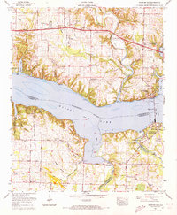 1971 Wheeler Dam1973 Print · USGSIn the early 1970s, the Tennessee River valley near the tri-county border was shaped by hydroelectric power and rising lakes. Genealogists and local historians can trace family landmarks like Fosters Mill, Hennigan Cem, and Center Star across this evolving landscape.2 unique versions available
 - 1974 Map of Town Creek, 1975 Print
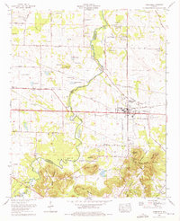 1974 Town Creek1975 Print · USGSThe community of Town Creek is captured in the mid-1970s, flourishing along the Southern Railway at the Colbert and Lawrence county line. Local historians can trace dozens of family landmarks, from Winston Quarters and Hazlewood High School to the quiet Stanley Cem.2 unique versions available
 - 1974 Map of Rogersville, 1975 Print
 1974 Rogersville1975 Print · USGSThe Tennessee River and Elk River converge in Lauderdale County during the mid-seventies, a time of established lakeside communities. Researchers can trace family history through dozens of rural burial grounds like Romine Ch Cem and landmarks such as Saltpeter Cave Bluff.
 - 1974 Map of Courtland, 1975 Print
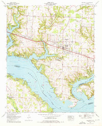
 1974 Courtland1975 Print · USGSThe town of Courtland and the Tennessee River shoreline are captured here in the mid-seventies, showing a landscape defined by the Southern railroad and river history. Genealogists can locate over twenty cemeteries and former plantation sites like Sherrod Quarters or the sprawling Courtland Air Base (abandoned).
 - 1974 Map of Hillsboro, 1975 Print
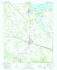
 1974 Hillsboro1975 Print · USGSHillsboro and the banks of the Tennessee River are captured here in the mid-seventies as industry and tradition met. Family historians can locate dozens of burial sites like Shackelford Cem and Graves Cem Church alongside the Southern Railway.
 - 1976 Map of Jones Crossroads, 1977 Print
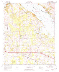
 1976 Jones Crossroads1977 Print · USGSThe Tennessee River valley north of Decatur underwent significant industrial transformation by the mid-seventies. Researchers can trace family history through numerous burial sites like Malone Cem or locate the sprawling Browns Ferry Nuclear Plant.
End of results
Showing maps 1-6 of 6
Top cities of Lawrence County
- Moulton historical maps
- Town Creek historical maps
- Courtland historical maps
- North Courtland historical maps
- Hillsboro historical maps
- Hatton historical maps
Frequently asked questions
- What are the different types of historical maps available for Lawrence County?
- What is the oldest map of Lawrence County?
- Where can I purchase historical maps of Lawrence County for my home or office?
- Where can I download high-res historical maps of Lawrence County?
- Are there historical topographic maps available for Lawrence County?
- Is there historical aerial imagery available for Lawrence County?
- Where are historical maps of Lawrence County sourced from?