1970s Maps of Lee County, Alabama
Explore 10 historic maps of Lee County from the 1970s. These maps offer a rare glimpse into what life looked like during the 1970s — showing old roads, neighborhoods, homes, and landmarks that have changed or disappeared over time.
Whether you're researching your family's past, planning a metal detecting trip, or studying how Lee County's landscape evolved across the 1970s, these high-resolution maps are a powerful tool for exploring the history of this region.
- Focus on a specific era: All maps on this page are from the 1970s, giving you a focused view of this time period.
- See what’s changed: Compare century-old streets, trails, and buildings to today's modern landscape using overlays and satellite layers.
- Research with precision: Use these maps for genealogy, historical research, land use analysis, or educational projects.
- View, download, or print: Maps are fully viewable online in high resolution, and can be downloaded or printed for your own records.
Start exploring Lee County's history through authentic maps from the 1970s. This is your window into the past.
Lee County, AL maps
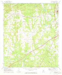
(10)- 1970 Map of Opelika East, 1973 Print
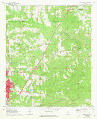 1970 Opelika East1973 Print · USGSOpelika experienced significant industrial and educational growth in the early seventies, centered around its vital rail junctions. Researchers can trace the development of local schools like Darden High Sch and find family-named sites such as Scott Cem and Beans Mill.4 unique versions available
 - 1971 Map of Waverly
 1971 Waverly1971 Print · USGSThe intersection of Lee, Chambers, and Tallapoosa counties in the early 1970s shows a landscape of rail-linked communities and rural crossroads. Genealogists can trace family footprints near Waverly, Gold Hill, and historic churches like Mt Traveler Ch or Macon Spring Ch.2 unique versions available
 - 1971 Map of Parkers Crossroads, 1973 Print
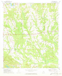
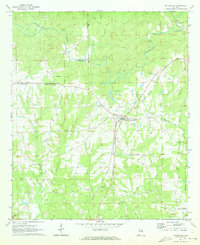
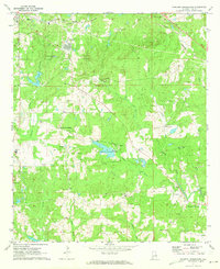 1971 Parkers Crossroads1973 Print · USGSLee County's rural crossroads and creek-side mills are documented here just as the early seventies began. Genealogists and local historians can trace family landmarks like Brown Cem, the Beauregard Sch, and the old rail line of the Central of Georgia.2 unique versions available
 - 1971 Map of Opelika West, 1973 Print
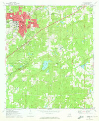
 1971 Opelika West1973 Print · USGSThe growing communities of Opelika and Auburn meet in this 1970s portrait of Lee County's rail and water infrastructure. Researchers can trace historic family landmarks and local institutions like Oak Bowery Ch, The Bottle, and the Central of Georgia Railway.3 unique versions available
 - 1971 Map of Loachapoka, 1973 Print
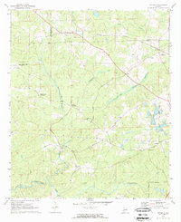
 1971 Loachapoka1973 Print · USGSLoachapoka and the rural Lee-Macon county line are seen here in the early seventies, centered on the historic Western Railway of Alabama. Researchers can trace the layout of local education and faith at Loachapoka Jr High Sch, Coster Ch, and the Loachapoka Cem.3 unique versions available
 - 1971 Map of Marvyn, 1973 Print
 1971 Marvyn1973 Print · USGSThe rural borderlands of Lee and Russell counties are captured here in the early seventies, centered on the community of Marvyn. Researchers can trace old family sites and local foundations like Jenkins Cem, Waboola Ch, and the Dixie Sch.2 unique versions available
 - 1971 Map of Thornton, 1973 Print
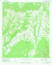
 1971 Thornton1973 Print · USGSTallapoosa and Lee counties are captured here in the early seventies, showing a landscape of scattered rural settlements and winding creek bottoms. Genealogists can trace family connections through numerous country landmarks like New Hope Cem Ch, Thornton, and Antioch Ch.
 - 1971 Map of Society Hill, 1973 Print
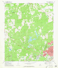
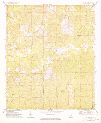
 1971 Society Hill1973 Print · USGSSociety Hill stood as a quiet rural crossroads in the early 1970s at the intersection of Lee, Macon, and Russell counties. Genealogists and local historians can trace family ties through numerous landmarks like Cobbs Cem, Society Hill Cem, and Reese Chapel.2 unique versions available
 - 1971 Map of Auburn, 1973 Print
 1971 Auburn1973 Print · USGSAuburn and Opelika are shown during a period of significant academic and civic expansion in the early seventies. Local historians can trace the development of Auburn University and locate rural landmarks like Mitchell Crossroads and Sand Hill Ch.2 unique versions available
 - 1971 Map of Notasulga, 1973 Print
 1971 Notasulga1973 Print · USGSNotasulga and its rural Alabama surroundings are captured here in the early 1970s, as the town thrived along the Western Railway of Alabama. Genealogists and local historians can locate many country landmarks, including McRitchie Mill, Bethlehem Cemetery, and Lockets Chapel.2 unique versions available
End of results
Showing maps 1-10 of 10
Top cities of Lee County
- Auburn historical maps
- Opelika historical maps
- Smiths Station historical maps
- Loachapoka historical maps
Frequently asked questions
- What are the different types of historical maps available for Lee County?
- What is the oldest map of Lee County?
- Where can I purchase historical maps of Lee County for my home or office?
- Where can I download high-res historical maps of Lee County?
- Are there historical topographic maps available for Lee County?
- Is there historical aerial imagery available for Lee County?
- Where are historical maps of Lee County sourced from?