1970s Maps of Shelby County, Alabama
Explore 28 historic maps of Shelby County from the 1970s. These maps offer a rare glimpse into what life looked like during the 1970s — showing old roads, neighborhoods, homes, and landmarks that have changed or disappeared over time.
Whether you're researching your family's past, planning a metal detecting trip, or studying how Shelby County's landscape evolved across the 1970s, these high-resolution maps are a powerful tool for exploring the history of this region.
- Focus on a specific era: All maps on this page are from the 1970s, giving you a focused view of this time period.
- See what’s changed: Compare century-old streets, trails, and buildings to today's modern landscape using overlays and satellite layers.
- Research with precision: Use these maps for genealogy, historical research, land use analysis, or educational projects.
- View, download, or print: Maps are fully viewable online in high resolution, and can be downloaded or printed for your own records.
Start exploring Shelby County's history through authentic maps from the 1970s. This is your window into the past.
Shelby County, AL maps
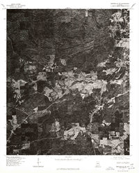
(28)- 1975 Map of Laniers, 1976 Print
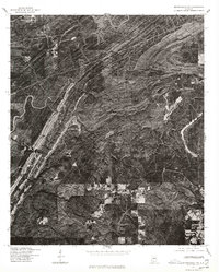
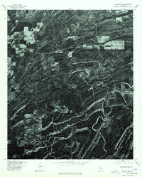
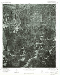
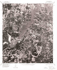 1975 Laniers1976 Print · USGSThe Alabama landscape near the Coosa River is captured in the mid-seventies just as the shoreline began to develop. Researchers can trace the winding branches of Logan Martin Lake and locate the small settlement of Laniers amidst the woods and fields.
 - 1975 Map of Westover, 1977 Print
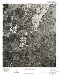
 1975 Westover1977 Print · USGSShelby County emerges in the mid-seventies through this detailed aerial survey, showing the rural landscape around Westover. Researchers can trace the development of local road networks and identify specific cleared homesteads and pastures in the era before modern expansion.
 - 1975 Map of Vincent, 1977 Print
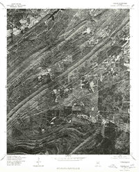
 1975 Vincent1977 Print · USGSShelby County in the mid-seventies is revealed through this detailed orthophoto survey, showing the town and its rural surroundings with photographic precision. Local historians can trace the clearings and road patterns around Vincent as they existed before modern expansion.
 - 1975 Map of Cahaba Heights, 1977 Print
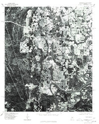
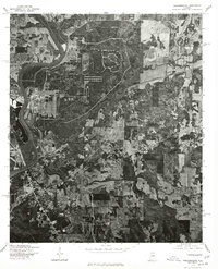
 1975 Cahaba Heights1977 Print · USGSThe suburbs of Shelby County are frozen in the mid-seventies, showing the transition from wooded ridges to residential neighborhoods. Researchers can trace the early footprints of Mountain Brook and the growing streets of Cahaba Heights as they looked decades ago.
 - 1975 Map of Montevallo SW, 1977 Print
 1975 Montevallo SW1977 Print · USGSBibb County timberlands and small settlements are captured in high detail in the mid-seventies just as modern land-use patterns emerged. Genealogists and local historians can trace the clearings and crossroads around Aldrich and the historic area of Brierfield.
 - 1975 Map of Helena, 1977 Print
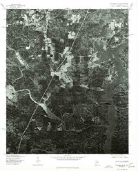
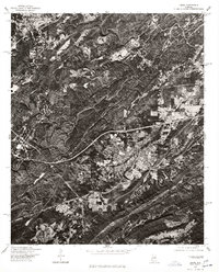
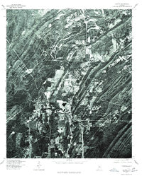 1975 Helena1977 Print · USGSShelby County emerges in the mid-seventies in this aerial survey, showing the landscape just as suburban growth began to take hold. Researchers can trace the original footprint of Helena and follow the winding course of the Cahaba River.
 - 1975 Map of Montevallo SE, 1977 Print
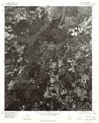
 1975 Montevallo SE1977 Print · USGSCentral Alabama in the mid-seventies is documented here through high-resolution aerial imagery centered on the corridor between two key towns. Local historians can trace industrial growth and land use patterns around Montevallo and Calera.
 - 1975 Map of Gantts Quarry NW, 1977 Print
 1975 Gantts Quarry NW1977 Print · USGSThe mid-Alabama landscape comes into focus in the mid-1970s as the Coosa River winds toward the settlement of Wilsonville. Researchers can trace the wooded shorelines and rural clearings surrounding the wide waters of Lay Lake.
 - 1975 Map of Birmingham South, 1977 Print
 1975 Birmingham South1977 Print · USGSThe suburban landscape south of Birmingham is captured in detail during the mid-seventies, showing the region's mid-century growth. Researchers can trace the development of residential neighborhoods and road networks through Homewood and Mountain Brook.
 - 1975 Map of Cooks Springs, 1977 Print
 1975 Cooks Springs1977 Print · USGSSt. Clair County appears in high-detail aerial imagery during the mid-seventies, showing the ridge-and-valley landscape of central Alabama. Genealogists and historians can pinpoint homesites and property boundaries near Cooks Springs, Moody, and Prescott.
 - 1975 Map of Greenwood, 1977 Print
 1975 Greenwood1977 Print · USGSJefferson County residential and industrial clearings are captured during the mid-seventies in this detailed aerial orthophoto. Researchers can trace the development of Greenwood and Parkwood or follow the winding path of the Cahaba River.
 - 1975 Map of Columbiana SE, 1977 Print
 1975 Columbiana SE1977 Print · USGSThe community of Shelby is captured in the mid-seventies as it transitions from the wooded uplands to the winding banks of the Coosa River. Genealogists and local historians can trace the rural road networks and the exact 1970s shoreline of the river valley.
 - 1975 Map of Vandiver, 1977 Print
 1975 Vandiver1977 Print · USGSShelby County land patterns and ridge-top forests are revealed in this 1970s aerial study. Local historians and genealogists can trace property boundaries and rural roads around Vandiver and the waters of Wehapa Lake.
 - 1975 Map of Columbiana NE, 1977 Print
 1975 Columbiana NE1977 Print · USGSShelby County transitions into its modern landscape in the mid-seventies, captured here through detailed aerial photo-imagery. Researchers can trace the residential expansion of Columbiana and the winding course of the Coosa River along the eastern edge.
 - 1975 Map of Montevallo NW, 1977 Print
 1975 Montevallo NW1977 Print · USGSShelby County emerges in clear aerial detail during the mid-seventies, showing the intersection of heavy industry and the winding Cahaba River. Genealogists and historians can trace old road alignments and early surface mining footprints near the river's edge.
 - 1975 Map of Leeds, 1977 Print
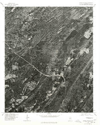
 1975 Leeds1977 Print · USGSJefferson County during the mid-seventies shows a landscape of growing towns and industrial sites set against the sharp ridges of central Alabama. Trace the development of Leeds and Trussville through direct aerial imagery from this era.
 - 1975 Map of Harpersville, 1977 Print
 1975 Harpersville1977 Print · USGSHarpersville and the Coosa River valley are seen here in the mid-seventies through detailed aerial imagery. Researchers can trace land use patterns and property boundaries near Harpersville or study the shoreline development along Lay Lake and Childersburg.
 - 1975 Map of Montevallo NE, 1977 Print
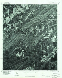
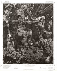 1975 Montevallo NE1977 Print · USGSShelby County enters a period of industrial and residential transition during the mid-seventies. Trace the development of Alabaster and the rural crossroads of Saginaw and Dogwood through detailed aerial imagery.
 - 1975 Map of Blocton NE, 1977 Print
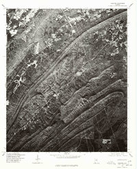
 1975 Blocton NE1977 Print · USGSIn the mid-1970s, the terrain of Bibb County was captured in striking detail via this aerial orthophotoquad. You can examine the settlement patterns around Green Pond and trace the timber tracks and ridgelines that define this rural landscape.
 - 1975 Map of Gantts Quarry SW, 1977 Print
 1975 Gantts Quarry SW1977 Print · USGSThe rural landscape of central Alabama comes into focus in the mid-1970s, showing the riverine topography and wooded uplands. Researchers can trace the layout of settlements like Marble Valley and Talladega Springs near the Coosa River.
 - 1975 Map of Chelsea, 1977 Print
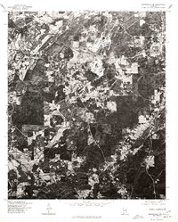
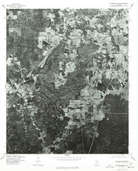
 1975 Chelsea1977 Print · USGSShelby County land patterns are captured in high-detail aerial imagery during the mid-seventies, showing the region before major modern expansion. Genealogists and local historians can trace early property boundaries and road networks around Chelsea and New Hope.
 - 1975 Map of Childersburg, 1977 Print
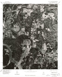
 1975 Childersburg1977 Print · USGSThe industrial and riverfront character of Talladega County comes into sharp focus in this mid-1970s orthophotograph. Genealogists and local historians can trace the precise residential layout of Childersburg and its proximity to the waters of Lay Lake and the Coosa River.
 - 1975 Map of Columbiana NW, 1977 Print
 1975 Columbiana NW1977 Print · USGSCovers Shelby County, including Alabaster, Calera, and other nearby areas
 - 1975 Map of Columbiana SW, 1977 Print
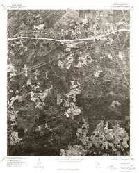
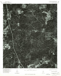 1975 Columbiana SW1977 Print · USGSThe Chilton County interior appears in sharp photographic detail during the mid-seventies, showing the fine-grained patterns of forest and timbering. Researchers can trace the path of Bumpratchet and examine the exact road network and field clearings of the era.
 - 1979 Map of Aldrich, 1980 Print
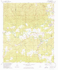 1979 Aldrich1980 Print · USGSBibb County in the late seventies reveals a landscape shaped by the iron industry and the Southern railway. Researchers can locate family landmarks like Carlton Hill Ch, Moore Cem, and the historic Bibb Furnace Ruins.2 unique versions available
Showing maps 1-25 of 28
Top cities of Shelby County
- Alabaster historical maps
- Pelham historical maps
- Helena historical maps
- Calera historical maps
- Chelsea historical maps
- Meadowbrook historical maps
See more
Frequently asked questions
- What are the different types of historical maps available for Shelby County?
- What is the oldest map of Shelby County?
- Where can I purchase historical maps of Shelby County for my home or office?
- Where can I download high-res historical maps of Shelby County?
- Are there historical topographic maps available for Shelby County?
- Is there historical aerial imagery available for Shelby County?
- Where are historical maps of Shelby County sourced from?