1980s Maps of Shelby County, Alabama
Explore 10 historic maps of Shelby County from the 1980s. These maps offer a rare glimpse into what life looked like during the 1980s — showing old roads, neighborhoods, homes, and landmarks that have changed or disappeared over time.
Whether you're researching your family's past, planning a metal detecting trip, or studying how Shelby County's landscape evolved across the 1980s, these high-resolution maps are a powerful tool for exploring the history of this region.
- Focus on a specific era: All maps on this page are from the 1980s, giving you a focused view of this time period.
- See what’s changed: Compare century-old streets, trails, and buildings to today's modern landscape using overlays and satellite layers.
- Research with precision: Use these maps for genealogy, historical research, land use analysis, or educational projects.
- View, download, or print: Maps are fully viewable online in high resolution, and can be downloaded or printed for your own records.
Start exploring Shelby County's history through authentic maps from the 1980s. This is your window into the past.
Shelby County, AL maps
(10)- 1980 Map of Alabaster
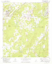
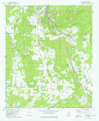 1980 Alabaster1980 Print · USGSShelby County at the start of the 1980s reveals a landscape of limestone mining and growing rural settlements along the rail lines. Researchers can trace family sites like Benton Cem, small communities at Elliotsville, and the Flying X Ranch Landing Strip.3 unique versions available
 - 1980 Map of Shelby
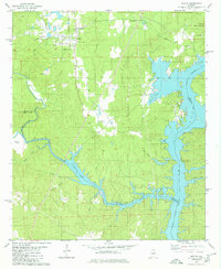 1980 Shelby1980 Print · USGSShelby and the surrounding lakefront are captured here in the early eighties as the town and the Coosa River landscape evolved. Local researchers can trace family landmarks like Brasher Cem and Bay Spring Ch or the winding path of Waxahatchee Creek.2 unique versions available
 - 1980 Map of Halfmile Shoals
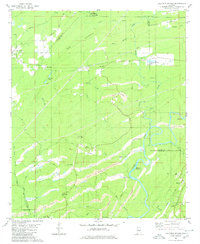 1980 Halfmile Shoals1980 Print · USGSThe Cahaba River corridor in the early eighties reveals a landscape shaped by coal mining and rural heritage at the junction of four counties. Researchers can trace historic settlements like Belle Ellen and Marvel, or locate landmarks such as McKensey Cem and Tannehill State Park.2 unique versions available
 - 1980 Map of Columbiana
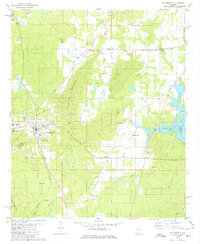 1980 Columbiana1980 Print · USGSShelby County’s seat and its surrounding rural crossroads are frozen in time during the late twentieth century. Genealogists and local researchers can trace family lines through Pine Lawn Gardens, Bethel Ch, and the old settlement at Nelson.
 - 1980 Map of Montevallo
 1980 Montevallo1980 Print · USGSMontevallo and Calera are captured here in the 1980s, revealing a landscape shaped by the rail industry and limestone extraction. Genealogists and historians can trace family markers at Old Rock Springs Cem or locate the Covered Bridge on Spring Creek.3 unique versions available
 - 1980 Map of Bounds Lake
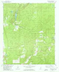 1980 Bounds Lake1980 Print · USGSShelby County in the late 1970s shows a landscape of ridge-top lookouts and historic valley settlements. Genealogists can locate family landmarks like Old Soldiers Cem, the Pilgrim Rest Ch, and the rural community of Mount Era.2 unique versions available
 - 1980 Map of Wilsonville
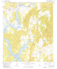 1980 Wilsonville1980 Print · USGSThe Shelby and Talladega county lines meet along the impounded Coosa River in the late seventies. Researchers can trace the river's influence on local life, from the Perkins Ferry site to rural landmarks like Kahatchee Cem and Shelby Shores.2 unique versions available
 - 1984 Map of Tuscaloosa, 1985 Print
 1984 Tuscaloosa1985 Print · USGSWest-central Alabama centers on the mid-1980s expansion of the university and the river economy. Genealogists and historians can trace small-town connections through Burchfield Store, North Johns, and the rail lines of the Southern railroad.2 unique versions available
 - 1984 Map of Birmingham South, 1985 Print
 1984 Birmingham South1985 Print · USGSThe Birmingham metropolitan region and the Coosa River valley are shown here in the mid-eighties as suburban growth expanded south into the ridges. Genealogists and local historians can trace the development of communities from Bessemer to Sylacauga alongside the Lay Lake shoreline and the Talladega National Forest.2 unique versions available
 - 1984 Map of Birmingham North, 1985 Print
 1984 Birmingham North1985 Print · USGSNorth Alabama in the mid-eighties shows the bustling intersection of the Appalachian foothills and the Deep South's industrial heart. Genealogists and historians can trace the paths of the Southern Railway and Seaboard System Railroad through towns like Oneonta, Leeds, and Springville.2 unique versions available
End of results
Showing maps 1-10 of 10
Top cities of Shelby County
- Alabaster historical maps
- Pelham historical maps
- Helena historical maps
- Calera historical maps
- Chelsea historical maps
- Meadowbrook historical maps
See more
Frequently asked questions
- What are the different types of historical maps available for Shelby County?
- What is the oldest map of Shelby County?
- Where can I purchase historical maps of Shelby County for my home or office?
- Where can I download high-res historical maps of Shelby County?
- Are there historical topographic maps available for Shelby County?
- Is there historical aerial imagery available for Shelby County?
- Where are historical maps of Shelby County sourced from?