Old Maps of Sumter County, Alabama for Hiking & Exploration
Hike through history with 172 historic maps of Sumter County. Explore old trails, ghost towns, and forgotten backroads — perfect for outdoor adventurers and local explorers.
- Rediscover forgotten places: Map out old mining camps, roads, and footpaths that no longer exist on modern maps.
- Layer with modern tools: Combine with LiDAR or satellite views to plan hikes through historical terrain.
- Made for exploration: Popular among hikers, overlanders, and local history lovers.
Use these maps to find adventure and explore the hidden past of Sumter County.
Sumter County, AL maps
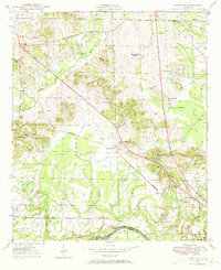
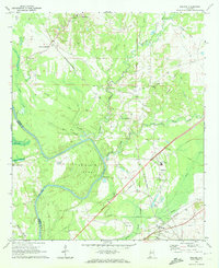
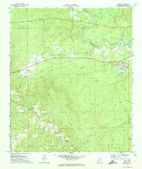
(172)- 1929 Map of Epes
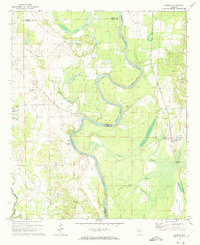
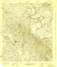 1929 Epes1929 Print · USGSThe Tombigbee and Sucarnoochee rivers meet in this 1920s portrait of West Alabama. Genealogists can trace family roots at Livingston or search for old schoolhouses like the Ezell Sch and rural landmarks like Hixon Switch.
 - 1932 Map of Epes
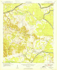
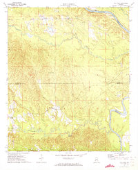
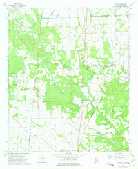
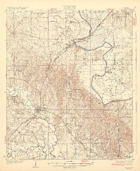 1932 Epes1932 Print · USGSSumter and Greene counties are shown in the early 1930s as the regional economy relied heavily on the Southern Railway and river transport. Genealogists can locate family landmarks like Wesley Chapel, Hillman Ferry, and the Industrial School.4 unique versions available
 - 1946 Map of Demopolis, 1947 Print
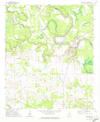
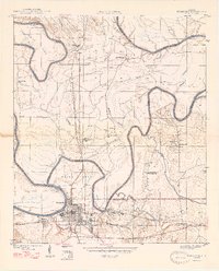 1946 Demopolis1947 Print · USGSDemopolis and its surrounding river bends are captured here in the mid-1940s, showing a landscape defined by the Tombigbee and Black Warrior rivers. Genealogists and historians can trace community roots through numerous local landmarks like Jerusalem Ch, Birdine Junior High Sch, and Merriwether Ferry.3 unique versions available
 - 1947 Map of Demopolis
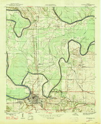 1947 Demopolis1947 Print · USGSDemopolis and its surroundings were defined by the convergence of major rivers and railroads in the late 1940s. Genealogists and historians can trace community life through sites like the Rosenwald Sch, the Arington Cem, and landmarks such as Merriwether Ferry.
 - 1947 Map of Forkland, 1973 Print
 1947 Forkland1973 Print · USGSGreene County, Alabama, is documented here in the mid-1940s as the river-and-rail economy shaped local life. Researchers can trace family roots through numerous rural landmarks like Hard Bargain Cem, Thornhill Sta, and the Stonewall Taylor Sch.3 unique versions available
 - 1948 Map of Mc Dowell, 1973 Print
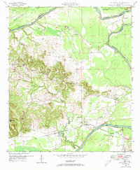 1948 Mc Dowell1973 Print · USGSSumter and Greene Counties are defined by the winding river and its early crossings in the late 1940s. Genealogists and historians can trace the foundations of rural life through landmarks like McDowell Ferry, Belmont Ch, and the Taylor Cem.3 unique versions available
 - 1949 Map of Mc Dowell
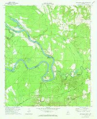
 1949 Mc Dowell1949 Print · USGSSumter County in the late 1940s is defined by its deep relationship with the winding Tombigbee River. Genealogists and historians can trace family roots through numerous local landmarks like Bucks Chapel Sch, Belmont Ch, and the historic McDowell Ferry.2 unique versions available
 - 1949 Map of Forkland
 1949 Forkland1949 Print · USGSGreene County near the Tombigbee River in the late 1940s reveals a landscape of small schools and family-named landmarks. Trace the ST LOUIS SAN FRANCISCO rail line past Thornhill Sta or locate burial sites like Hard Bargain Cem.2 unique versions available
 - 1953 Map of Montgomery, 1964 Print
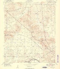
 1953 Montgomery1964 Print · USGSCentral Alabama's river-and-rail corridor is mapped here in the mid-fifties, showing the vital connections between the capital and the Black Belt. Genealogists and historians can trace rail depots and crossroads from Marion Junction to Wetumpka, alongside landmarks like Craig AFB.4 unique versions available
 - 1953 Map of Meridian, 1966 Print
 1953 Meridian1966 Print · USGSEast Central Mississippi and the Alabama borderlands are captured here during a period of steady growth and infrastructure expansion. Genealogists and historians can trace rail-town development along the Gulf Mobile & Ohio Railroad and find early settlements like Scooba, Pelahatchie, and De Kalb.2 unique versions available
 - 1956 Map of Montgomery
 1956 Montgomery1956 Print · USGSCentral Alabama in the mid-1950s shows a landscape defined by its great river systems and a booming military aviation presence. Genealogists and historians can trace the rail corridors of the Southern Railway and locate tactical bases like Maxwell AFB and Craig AFB.
 - 1957 Map of Meridian
 1957 Meridian1957 Print · USGSEast Central Mississippi and parts of Western Alabama come alive in the mid-1950s, centered on the transit hub of Meridian. Researchers can trace old rail lines like the Illinois Central and find historic sites such as the Choctaw Indian Reservation and Roosevelt State Park.
 - 1957 Map of Montgomery
 1957 Montgomery1957 Print · USGSCentral Alabama in the mid-fifties is defined by the winding Alabama River and a strategic network of military bases and rail lines. Trace family roots in Montgomery and Selma, or locate landmarks like Craig AFB and the State Capitol before the interstate era.
 - 1965 Map of Meridian
 1965 Meridian1965 Print · USGSEast Mississippi and West Alabama are mapped here in the mid-sixties as the region's modern highway and reservoir systems began to take shape. Researchers can trace rural lineages through local landmarks like Prince Chapel and Tuscahoma Landing, or follow the historic Gulf Mobile & Ohio rail lines.
 - 1970 Map of Boligee, 1972 Print
 1970 Boligee1972 Print · USGSGreene County near the river during the early seventies shows a landscape of small settlements and rail corridors. Genealogists can trace family landmarks like Lizzieville, the County Training School, and Boatright Cem near the Tombigbee River.3 unique versions available
 - 1970 Map of Gainesville, 1972 Print
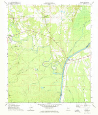
 1970 Gainesville1972 Print · USGSGainesville and the surrounding riverlands of Sumter and Greene Counties are captured here in the early seventies as the Tombigbee continues its slow meander through the deep south. Genealogists and historians can trace community roots through numerous country churches like New Bethel Ch or locate the Old Cem and Old Railroad Grade near the river.2 unique versions available
 - 1970 Map of Myrtlewood North, 1973 Print
 1970 Myrtlewood North1973 Print · USGSMarengo County and its neighbors meet along the winding river bends of the Tombigbee in the late sixties. Genealogists and local historians can trace family locations near Myrtlewood, Hill Top, and country churches like New Macedonia Ch.
 - 1970 Map of Jefferson, 1973 Print
 1970 Jefferson1973 Print · USGSThe Tombigbee River valley in Marengo County comes into focus during the early seventies, detailing the rural communities of Jefferson and Moscow. Researchers can trace old rail lines like the Southern and find landmarks such as Essex Sch and Salt Well.3 unique versions available
 - 1970 Map of Warsaw, 1973 Print
 1970 Warsaw1973 Print · USGSThe Tombigbee River borderlands in the early 1970s showcase a landscape of winding bends and rural river settlements. Genealogists can trace family roots through several landmarks like Hargrove Cem, St Johns Ch, and the community of Warsaw.2 unique versions available
 - 1971 Map of Whitfield, 1973 Print
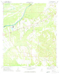
 1971 Whitfield1973 Print · USGSChoctaw County’s rural river border comes into focus in the early 1970s as the Tombigbee meanders past local settlements. Genealogists can trace community roots at Bethlehem Cem and Edna, or locate the path of the Kinterbish Railroad Grade.
 - 1971 Map of Coatopa, 1974 Print
 1971 Coatopa1974 Print · USGSSumter and Marengo counties meet at the Tombigbee River in the early 1970s, where river culture and rail history intersect. Genealogists can trace local roots at Marys Chapel Cem, Mt Tabor Ch, and the crossing at Rooster Bridge.4 unique versions available
 - 1971 Map of Gaston, 1974 Print
 1971 Gaston1974 Print · USGSThe Sumter and Choctaw county line area comes to life in the early 1970s, showing a landscape of deep creek valleys and quiet rural crossroads. Genealogists and historians can locate family landmarks like Gaston Valley Ch, the community of Derby, and the winding course of Kinterbish Creek.3 unique versions available
 - 1971 Map of Bellamy, 1974 Print
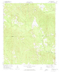
 1971 Bellamy1974 Print · USGSSumter County in the early seventies is a landscape of timber-focused rail lines and small country settlements. Genealogists and historians can locate old rural hubs like Intercourse, Lilita, and Curl Station, along with numerous landmarks like Morning Star Ch and Lamkin Sch.2 unique versions available
 - 1973 Map of Panola, 1975 Print
 1973 Panola1975 Print · USGSThe borderlands of Alabama and Mississippi come into focus in the early seventies, centered on the Noxubee River bottoms. Researchers can trace family sites at Mt Tabor Ch Cem and St Marys Ch or follow the St Louis-San Francisco rail line.2 unique versions available
 - 1973 Map of Geiger, 1975 Print
 1973 Geiger1975 Print · USGSThe Alabama-Mississippi borderlands come into focus in the early 1970s, showing a landscape defined by the St Louis-San Francisco railroad and rural creek bottoms. Genealogists can trace family landmarks like Souls Chapel Cem and Jerusalem Ch along the meandering Bodka Creek.2 unique versions available
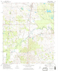
Showing maps 1-25 of 172
Top cities of Sumter County
- Livingston historical maps
- York historical maps
- Bellamy historical maps
- Cuba historical maps
- Epes historical maps
- Gainesville historical maps
See more
Frequently asked questions
- What are the different types of historical maps available for Sumter County?
- What is the oldest map of Sumter County?
- Where can I purchase historical maps of Sumter County for my home or office?
- Where can I download high-res historical maps of Sumter County?
- Are there historical topographic maps available for Sumter County?
- Is there historical aerial imagery available for Sumter County?
- Where are historical maps of Sumter County sourced from?