
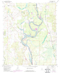
1970 Map of Warsaw
USGS Topo · Published 1973About this map
The Tombigbee River carves a winding path through the borderlands of Sumter, Greene, and Pickens Counties, defining a landscape shaped by water and shifting riverbeds. This 1970s view reveals a rural economy centered on the river and rail, with the St Louis-San Francisco line cutting through the eastern edge of the quadrangle. Several family-named landmarks and rural congregations like Mt Pleasant Ch and Zion Valley Ch anchor the small communities of Warsaw and Jamestown.
Find a feature on this map
41 named features on this map. Tap any name to fly to it.
Don’t see what you’re looking for? This feature index may not catch every label — zoom into the map to look around manually.
Map Details
Editions of this 1970 Warsaw Map
2 editions found
Other maps of this area

1953 · Meridian
USGS Topo · 1:250,000

1953 · West Point
USGS Topo · 1:250,000

1957 · Meridian
USGS Topo · 1:250,000

1958 · West Point
USGS Topo · 1:250,000

1963 · West Point
USGS Topo · 1:250,000

1965 · Meridian
USGS Topo · 1:250,000
1970 · Pleasant Ridge
USGS Topo · 1:24,000
1970 · West Greene
USGS Topo · 1:24,000
1970 · Boligee
USGS Topo · 1:24,000

1970 · Gainesville
USGS Topo · 1:24,000