
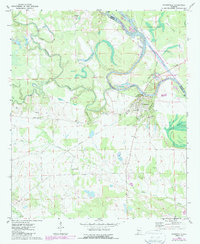
1970 Map of Gainesville
USGS Topo · Published 1972About this map
Gainesville occupies a bend in the Tombigbee River in western Alabama, where the river's winding course forms the boundary between Sumter and Greene Counties. The landscape is defined by the convergence of major waterways, including the Noxubee River and Bodka Creek, creating a complex network of wetlands such as Cypress Swamp and Woodward Lakes. This 1970 snapshot of the region shows a rural community centered on its local institutions, with numerous rural congregations like Antioch Ch and New Bethel Ch dotting the countryside. Evidence of earlier transportation networks persists through the presence of an Old Railroad Grade and the Tutwiler Bridge, which spans the Tombigbee. The town's historical significance is further reflected in landmarks like the Forrest Memorial and several dedicated burial grounds, including the Old Cem near the riverbank.
Find a feature on this map
28 named features on this map. Tap any name to fly to it.
Don’t see what you’re looking for? This feature index may not catch every label — zoom into the map to look around manually.
Map Details
Editions of this 1970 Gainesville Map
2 editions found
Other maps of this area

1929 · Epes
USGS Topo · 1:48,000

1932 · Epes
USGS Topo · 1:62,500

1953 · Meridian
USGS Topo · 1:250,000

1957 · Meridian
USGS Topo · 1:250,000

1965 · Meridian
USGS Topo · 1:250,000
1970 · West Greene
USGS Topo · 1:24,000
1970 · Boligee
USGS Topo · 1:24,000

1970 · Warsaw
USGS Topo · 1:24,000

1973 · Panola
USGS Topo · 1:24,000
1973 · Geiger
USGS Topo · 1:24,000