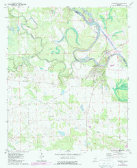
1970 Map of Gainesville
USGS Topo · Published 1987About this map
The Gainesville community sits at a critical bend where the Tombigbee River meets the Tennessee-Tombigbee Waterway on the border of Greene and Sumter counties. This era of the landscape is defined by massive water management projects, including the Gainesville Dam and Gainesville Lock, which transformed the natural flow of the river into Gainesville Lake and Lake Demopolis. Evidence of the area's civil and religious history is visible in landmarks like the Forrest Memorial and local congregations such as St Albans Ch and New Bethel Ch.
Find a feature on this map
32 named features on this map. Tap any name to fly to it.
Don’t see what you’re looking for? This feature index may not catch every label — zoom into the map to look around manually.
Map Details
Editions of this 1970 Gainesville Map
2 editions found
Other maps of this area

1929 · Epes
USGS Topo · 1:48,000

1932 · Epes
USGS Topo · 1:62,500

1953 · Meridian
USGS Topo · 1:250,000

1957 · Meridian
USGS Topo · 1:250,000

1965 · Meridian
USGS Topo · 1:250,000
1970 · West Greene
USGS Topo · 1:24,000
1970 · Boligee
USGS Topo · 1:24,000

1970 · Gainesville
USGS Topo · 1:24,000

1970 · Warsaw
USGS Topo · 1:24,000

1973 · Panola
USGS Topo · 1:24,000