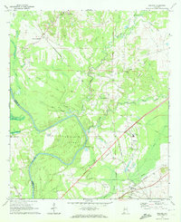
1970 Map of Boligee
USGS Topo · Published 1972About this map
The Tombigbee River forms the defining boundary of this West Alabama landscape, carving the dramatic Swilleys Bend along the line between Greene and Sumter Counties. In the early 1970s, this area remained deeply rooted in its rural character, anchored by small communities like Lizzieville and Crawford Fork. Cultural life centers around numerous country churches and cemeteries, such as St Pauls Ch, Morning Star Ch, and the Boatright Cem. The presence of the County Training School near Lizzieville speaks to the local educational history of the era. The terrain is a network of water and infrastructure, from the winding Trussells Creek and Cypress Swamp to the industrial mark of the St Louis-San Francisco railroad and the Southern line. Former transport points like Gladys Landing and numerous Gravel Pits indicate the river-and-rail based economy that shaped these settlements.
Find a feature on this map
41 named features on this map. Tap any name to fly to it.
Don’t see what you’re looking for? This feature index may not catch every label — zoom into the map to look around manually.
Map Details
Editions of this 1970 Boligee Map
3 editions found
Other maps of this area

1927 · Eutaw
USGS Topo · 1:48,000

1929 · Epes
USGS Topo · 1:48,000

1931 · Eutaw
USGS Topo · 1:62,500

1932 · Epes
USGS Topo · 1:62,500

1947 · Forkland
USGS Topo · 1:24,000

1949 · Forkland
USGS Topo · 1:24,000

1953 · Montgomery
USGS Topo · 1:250,000

1953 · Meridian
USGS Topo · 1:250,000

1956 · Montgomery
USGS Topo · 1:250,000

1957 · Meridian
USGS Topo · 1:250,000