
1973 Map of Panola
USGS Topo · Published 1975About this map
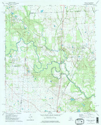
The Noxubee River meanders through the heart of this landscape, marking the historical borderlands where Pickens and Sumter Counties meet at the Mississippi-Alabama state line. The settlement of Panola serves as a local hub, situated along the St Louis-San Francisco railway which cuts diagonally across the terrain. This rural topography is defined by its watercourses, including Jones Creek and Caney Creek, which feed into the primary river system near Campbells Lake.
Find a feature on this map
27 named features on this map. Tap any name to fly to it.
Don’t see what you’re looking for? This feature index may not catch every label — zoom into the map to look around manually.
Map Details
Editions of this 1973 Panola Map
2 editions found
Other maps of this area

1953 · Meridian
USGS Topo · 1:250,000

1953 · West Point
USGS Topo · 1:250,000

1957 · Meridian
USGS Topo · 1:250,000

1958 · West Point
USGS Topo · 1:250,000

1963 · West Point
USGS Topo · 1:250,000

1965 · Meridian
USGS Topo · 1:250,000

1970 · Gainesville
USGS Topo · 1:24,000

1970 · Aliceville South
USGS Topo · 1:24,000

1970 · Warsaw
USGS Topo · 1:24,000

1973 · Scooba
USGS Topo · 1:24,000