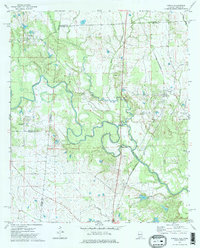
1973 Map of Panola
USGS Topo · Published 1975About this map
The Noxubee River snakes through the borderlands of Alabama and Mississippi, defining a landscape where rural settlements and community landmarks cluster along its winding course. In the early 1970s, the area around Panola and Cooksville remained a network of timberlands and small-scale agriculture, connected by the St Louis-San Francisco railroad line. Local social geography is anchored by numerous country churches, including St Marys Ch, Galilee Ch, and St Mark Ch, which served as the cornerstones of these small crossroads. Notable for genealogy and local history is the dual-purpose Mt Tabor Ch & Sch, reflecting an era when rural education and worship often shared a single community space. The terrain is further marked by its hydrology, with Beaver Creek and Rogers Creek feeding into the main river valley, alongside industrial indicators like a local Gravel Pit.
Find a feature on this map
25 named features on this map. Tap any name to fly to it.
Don’t see what you’re looking for? This feature index may not catch every label — zoom into the map to look around manually.
Map Details
Editions of this 1973 Panola Map
2 editions found
Other maps of this area

1953 · Meridian
USGS Topo · 1:250,000

1953 · West Point
USGS Topo · 1:250,000

1957 · Meridian
USGS Topo · 1:250,000

1958 · West Point
USGS Topo · 1:250,000

1963 · West Point
USGS Topo · 1:250,000

1965 · Meridian
USGS Topo · 1:250,000

1970 · Gainesville
USGS Topo · 1:24,000

1970 · Aliceville South
USGS Topo · 1:24,000

1970 · Warsaw
USGS Topo · 1:24,000

1973 · Panola
USGS Topo · 1:24,000