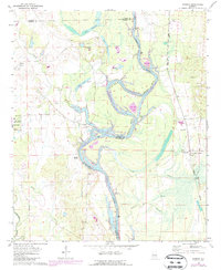
1970 Map of Warsaw
USGS Topo · Published 1987About this map
Warsaw sits at a critical bend where the Tombigbee River meets the modern Tennessee-Tombigbee Waterway. This area, marking the borders of Sumter, Greene, and Pickens counties, is defined by its deep connection to the river's path and the remnants of early settlement. The presence of numerous family burial grounds and congregations, such as Hargrove Cem, Jamestown Cem, and Shady Grove Ch, points to a long-established rural community fabric. The landscape is a network of backwater sloughs and lakes, including Gainesville Lake, Lake Hollolla, and Big Slough, which dominate the lowlands near China Bluff. An Old Railroad Grade on the eastern side of the river provides a physical record of former transportation corridors that once linked New West Greene to the wider region. Industrial activity is noted through localized Claypits and Gravel Pits, showing how the local geology supported regional development along the waterway.
Find a feature on this map
41 named features on this map. Tap any name to fly to it.
Don’t see what you’re looking for? This feature index may not catch every label — zoom into the map to look around manually.
Map Details
Editions of this 1970 Warsaw Map
2 editions found

Other maps of this area

1953 · Meridian
USGS Topo · 1:250,000

1953 · West Point
USGS Topo · 1:250,000

1957 · Meridian
USGS Topo · 1:250,000

1958 · West Point
USGS Topo · 1:250,000

1963 · West Point
USGS Topo · 1:250,000

1965 · Meridian
USGS Topo · 1:250,000
1970 · Pleasant Ridge
USGS Topo · 1:24,000
1970 · West Greene
USGS Topo · 1:24,000
1970 · Boligee
USGS Topo · 1:24,000

1970 · Gainesville
USGS Topo · 1:24,000