1960s Maps of Walker County, Alabama
Explore 8 historic maps of Walker County from the 1960s. These maps offer a rare glimpse into what life looked like during the 1960s — showing old roads, neighborhoods, homes, and landmarks that have changed or disappeared over time.
Whether you're researching your family's past, planning a metal detecting trip, or studying how Walker County's landscape evolved across the 1960s, these high-resolution maps are a powerful tool for exploring the history of this region.
- Focus on a specific era: All maps on this page are from the 1960s, giving you a focused view of this time period.
- See what’s changed: Compare century-old streets, trails, and buildings to today's modern landscape using overlays and satellite layers.
- Research with precision: Use these maps for genealogy, historical research, land use analysis, or educational projects.
- View, download, or print: Maps are fully viewable online in high resolution, and can be downloaded or printed for your own records.
Start exploring Walker County's history through authentic maps from the 1960s. This is your window into the past.
Walker County, AL maps
(8)- 1960 Map of Gadsden
 1960 Gadsden1960 Print · USGSNorthern Alabama in the mid-1950s is defined by the mighty Tennessee River and its massive reservoirs. Trace the development of Huntsville and Redstone Arsenal or explore the vast William B Bankhead National Forest.2 unique versions available
 - 1963 Map of Gadsden
 1963 Gadsden1963 Print · USGSNorthern Alabama underwent a dramatic mid-century transformation as the Tennessee Valley became a hub for defense and industry. Researchers can trace the development of the Redstone Arsenal, the route of the Natchez Trace Parkway, and long-standing rail lines like the Southern Railway.
 - 1967 Map of Carbon Hill, 1968 Print
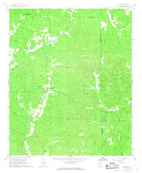
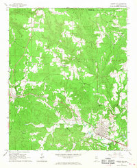 1967 Carbon Hill1968 Print · USGSWalker County and the Winston County border are captured in the late sixties, centered on the rail hub of Carbon Hill. Genealogists and historians can trace family-named sites like Walden Cem and Spring Hill, or the industrial strip mines and the Old Trinity Railroad Grade.3 unique versions available
 - 1967 Map of Hubbertville, 1968 Print
 1967 Hubbertville1968 Print · USGSNorthwest Alabama's rural hill country comes into focus in the late sixties as the Sipsey River winds through Fayette and Walker Counties. Genealogists and local historians can trace family sites like Killingsworth Ch Cem, Tidwell Chapel, and Hubbertville.2 unique versions available
 - 1967 Map of Glen Allen, 1968 Print
 1967 Glen Allen1968 Print · USGSNorthwest Alabama's coal and rail corridor comes to life in the late 1960s, showing the intersection of heavy industry and rural community life. Genealogists can trace family roots through landmarks like Hallmark Cem, Piney Grove Ch, and the settlement of Rock City.3 unique versions available
 - 1967 Map of Berry, 1968 Print
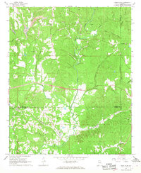
 1967 Berry1968 Print · USGSBerry and the surrounding Fayette County countryside are captured here in the late sixties as the local economy balanced rail transport and industrial mining. Family historians can locate dozens of specific landmarks like Tabernacle Cem, Boley Springs Ch, and the extensive strip mines near Pea Ridge.4 unique versions available
 - 1967 Map of Howard, 1968 Print
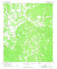
 1967 Howard1968 Print · USGSThe Fayette and Walker county line comes to life in the late sixties, showing a landscape of ridge-top settlements and creek-side hollows. Genealogists and local historians can trace family locations through numerous sites like Studdards Crossroads, Files Cem, and McDade Ch.3 unique versions available
 - 1969 Map of Arley, 1973 Print
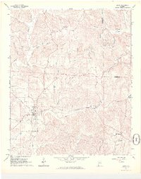
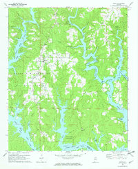 1969 Arley1973 Print · USGSArley and the northern reaches of the Smith Lake reservoir are shown here in the late sixties as the water reshaped the Winston County hills. Local historians can trace family roots through several landmarks like Robertson Chapel Cem, Arley Ch, and the Meek Lookout Tower.2 unique versions available
End of results
Showing maps 1-8 of 8
Top cities of Walker County
- Jasper historical maps
- Sumiton historical maps
- Dora historical maps
- Carbon Hill historical maps
- Cordova historical maps
- Parrish historical maps
See more
Frequently asked questions
- What are the different types of historical maps available for Walker County?
- What is the oldest map of Walker County?
- Where can I purchase historical maps of Walker County for my home or office?
- Where can I download high-res historical maps of Walker County?
- Are there historical topographic maps available for Walker County?
- Is there historical aerial imagery available for Walker County?
- Where are historical maps of Walker County sourced from?