1950s Maps of Walker County, Alabama
Explore 20 historic maps of Walker County from the 1950s. These maps offer a rare glimpse into what life looked like during the 1950s — showing old roads, neighborhoods, homes, and landmarks that have changed or disappeared over time.
Whether you're researching your family's past, planning a metal detecting trip, or studying how Walker County's landscape evolved across the 1950s, these high-resolution maps are a powerful tool for exploring the history of this region.
- Focus on a specific era: All maps on this page are from the 1950s, giving you a focused view of this time period.
- See what’s changed: Compare century-old streets, trails, and buildings to today's modern landscape using overlays and satellite layers.
- Research with precision: Use these maps for genealogy, historical research, land use analysis, or educational projects.
- View, download, or print: Maps are fully viewable online in high resolution, and can be downloaded or printed for your own records.
Start exploring Walker County's history through authentic maps from the 1950s. This is your window into the past.
Walker County, AL maps
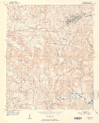
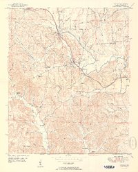
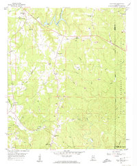
(20)- 1950 Map of Nauvoo
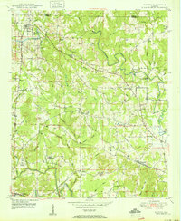 1950 Nauvoo1950 Print · USGSThe northern forest lands and rural settlements of Walker and Winston counties are detailed in this mid-century survey. Genealogists and local historians can trace the early layout of Nauvoo and its connection to the expansive William B Bankhead National Forest.2 unique versions available
 - 1950 Map of Manchester
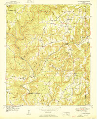
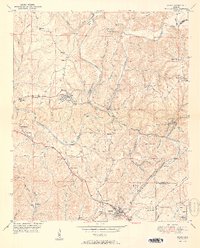
 1950 Manchester1950 Print · USGSWalker County during the mid-century period shows a landscape of rural schoolhouses and forest management just north of Jasper. Researchers can trace the Alabama Central RR (Abandoned) and locate vanished local landmarks like Hudson Settlement and the Bankhead Farmstead Sch.2 unique versions available
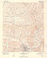
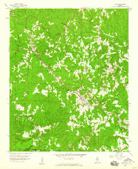
 - 1951 Map of Jasper
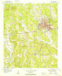 1951 Jasper1951 Print · USGSJasper and its surrounding coal-country communities are captured in the early 1950s as industry and aviation began to reshape the Walker County landscape. Genealogists and local historians can trace family roots at Oak Hill Cem, visit Snoddy Chapel, or locate schools like Scottsville Sch.2 unique versions available
 - 1951 Map of Cold Springs
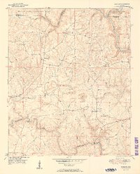
 1951 Cold Springs1951 Print · USGSCullman and Walker Counties are shown here just after mid-century as a landscape of rural ridge-top churches and river-bottom crossings. Genealogists can locate family landmarks like Addington Chapel, McKinley Chapel, and the community of Cold Springs.2 unique versions available
 - 1951 Map of Parrish
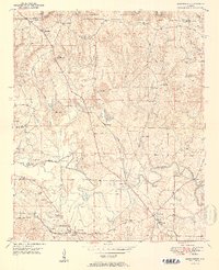
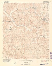
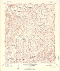
 1951 Parrish1951 Print · USGSWalker County in the early fifties shows a landscape of coal mining and rural settlements shaped by the Southern railroad. Researchers can trace family history at Old Liberty Hill Church, Ernest Chapel, and the community of Parrish.2 unique versions available
 - 1951 Map of Tutwiler School
 1951 Tutwiler School1951 Print · USGSThe borderlands of Walker and Tuscaloosa counties are documented here in the early fifties, showcasing a rural landscape shaped by the Black Warrior River. Genealogists can locate family landmarks like Tutwiler School, Browntown, and Reynolds Sch.2 unique versions available
 - 1951 Map of Oakman
 1951 Oakman1951 Print · USGSWalker and Fayette counties come into focus in the early fifties, showing the rail-dependent settlements of the coal region. Researchers can trace family history through several rural landmarks, including Mt Zion Ch, Infant Hill Cemetery, and the depot at Corona.2 unique versions available
 - 1951 Map of Sipsey
 1951 Sipsey1951 Print · USGSMid-century Walker County is shown here as a landscape of coal mining and river meanders just as the local industry peaked. Genealogists can trace family names at Rices Chapel, Maudlin Cem, and the rail junction at Sipsey.2 unique versions available
 - 1951 Map of Wiley
 1951 Wiley1951 Print · USGSTuscaloosa County is shown at mid-century as a land of rural homesteads and winding creek branches. Genealogists can trace family connections through landmarks like Brandon Sch, Rock Springs Ch, and the high ridges of Upton Hill.
 - 1951 Map of Townley
 1951 Townley1951 Print · USGSWalker County during the early postwar years reveals a landscape shaped by coal mining and close-knit rural communities. Genealogists and historians can trace family roots through sites like Palmer Sch, Kings Chapel, and the Manasco Cem near Townley.2 unique versions available
 - 1951 Map of Cordova
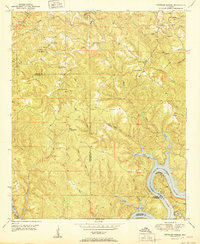
 1951 Cordova1951 Print · USGSWalker County at the start of the 1950s reveals a landscape defined by the Mulberry Fork river and a dense network of competing rail lines. Researchers can trace family roots through numerous local landmarks like Gardiners Gin, Sardis Cem, and the rural Wesley Ch.2 unique versions available
 - 1951 Map of Sunlight
 1951 Sunlight1951 Print · USGSWalker County at mid-century shows a landscape of forest and industry just as mining operations began to mark the terrain. Genealogists can trace family roots through numerous country churches like Mt Joy Ch and quiet burial grounds such as Tidwell Cem.2 unique versions available
 - 1951 Map of Creel, 1952 Print
 1951 Creel1952 Print · USGSNorth-Central Alabama in the early fifties was a region of high ridges and winding river forks where rural life centered on small crossroads. Genealogists can locate family landmarks at Partridge Crossroads, Red Hill Sch, and the New Zion Hill Ch community.5 unique versions available
 - 1953 Map of Birmingham, 1964 Print
 1953 Birmingham1964 Print · USGSCentral Alabama at mid-century shows a landscape defined by industrial expansion and the iron-rich ridges surrounding Birmingham. Researchers can trace the extensive rail networks of the L & N RR or locate historic federal sites like the Anniston Ordnance Depot.4 unique versions available
 - 1956 Map of Birmingham
 1956 Birmingham1956 Print · USGSCentral Alabama in the mid-fifties exhibits a landscape of growing cities and deep-rooted industrial corridors. Genealogists and historians can trace the development of suburban Mountain Brook or locate regional hubs like Sylacauga and Jasper.
 - 1956 Map of Gadsden, 1966 Print
 1956 Gadsden1966 Print · USGSNorth Alabama in the mid-1950s shows a region transformed by river engineering and federal industry. Genealogists and local historians can trace the development of the Tennessee Valley through the growth of Huntsville, the sprawling Redstone Arsenal, and the expansive Guntersville Lake.3 unique versions available
 - 1957 Map of Birmingham
 1957 Birmingham1957 Print · USGSNorth-Central Alabama in the mid-fifties is an industrial powerhouse centered on the steel valleys and sprawling iron ridges. Genealogists and historians can trace the rail-linked growth of Birmingham and Tuscaloosa, or locate rural landmarks like Talladega College and the Anniston Ordnance Depot.
 - 1958 Map of Gadsden
 1958 Gadsden1958 Print · USGSNorth Alabama comes alive in the late 1950s as the Tennessee Valley Authority’s massive river projects and the rise of the space industry reshaped the landscape. Researchers can trace the mid-century footprints of Huntsville, Redstone Arsenal, and the riverside rail networks of the Southern railroad.
 - 1958 Map of Gold Mine, 1960 Print
 1958 Gold Mine1960 Print · USGSMarion County during the late 1950s was a landscape of transitioning industries and deep-rooted rural communities. Local historians can trace the development of extraction sites like Gold Mine and Brilliant alongside landmarks such as Bethel Ch and Crooked Creek Cem.4 unique versions available
 - 1958 Map of Lynn, 1960 Print
 1958 Lynn1960 Print · USGSWinston County was a landscape of timber and rail in the years following the war. Researchers can trace the path of the Southern Line through Lynn or locate family history at Dodd Memorial Cem and Philadelphia Ch.3 unique versions available
End of results
Showing maps 1-20 of 20
Top cities of Walker County
- Jasper historical maps
- Sumiton historical maps
- Dora historical maps
- Carbon Hill historical maps
- Cordova historical maps
- Parrish historical maps
See more
Frequently asked questions
- What are the different types of historical maps available for Walker County?
- What is the oldest map of Walker County?
- Where can I purchase historical maps of Walker County for my home or office?
- Where can I download high-res historical maps of Walker County?
- Are there historical topographic maps available for Walker County?
- Is there historical aerial imagery available for Walker County?
- Where are historical maps of Walker County sourced from?