2000-2009 Maps of Alaska
Explore 33 historic maps of Alaska from 2000-2009. These maps offer a rare glimpse into what life looked like during the 2000s — showing old roads, neighborhoods, homes, and landmarks that have changed or disappeared over time.
Whether you're researching your family's past, planning a metal detecting trip, or studying how Alaska's landscape evolved across the 2000s, these high-resolution maps are a powerful tool for exploring the history of this region.
- Focus on a specific era: All maps on this page are from the 2000s, giving you a focused view of this time period.
- See what’s changed: Compare century-old streets, trails, and buildings to today's modern landscape using overlays and satellite layers.
- Research with precision: Use these maps for genealogy, historical research, land use analysis, or educational projects.
- View, download, or print: Maps are fully viewable online in high resolution, and can be downloaded or printed for your own records.
Start exploring Alaska's history through authentic maps from the 2000s. This is your window into the past.
Alaska maps
(33)- 2000 Map of Seward A-4, 2002 Print
 2000 Seward A-42002 Print · USGSCoastal Prince William Sound in the early twenty-first century is a landscape of massive tidewater ice and seasonal marine transit. Researchers can trace the Alaska Marine Highway past the Bainbridge Glacier or locate the Mine near Eleshansky Cove.
 - 2000 Map of Seward B-3, 2002 Print
 2000 Seward B-32002 Print · USGSWestern Prince William Sound is captured here at the turn of the millennium, showing a landscape defined by isolated coastal outposts and maritime routes. Researchers can locate the Chenega (Site), the New Year Islands Lighthouse Reserve, and the docks at Port Audrey.
 - 2000 Map of Cordova C-4, 2002 Print
 2000 Cordova C-42002 Print · USGSCoastal Alaska at the turn of the millennium shows a landscape shaped by ice and water within the Chugach National Forest. Trace the paths of the Scott Glacier and Sherman Glacier or locate early access routes like the Elsner Trail and Cabin Lake Road.
 - 2000 Map of Cordova B-5, 2002 Print
 2000 Cordova B-52002 Print · USGSThe Copper River Delta is captured here as a massive tidal wilderness at the turn of the millennium. Researchers can trace remote island navigation and drainage patterns across Egg Island Channel, Copper Sands, and the rugged slopes of the Heney Range.
 - 2000 Map of Cordova C-7, 2002 Print
 2000 Cordova C-72002 Print · USGSThe coastal wilderness of the Chugach shoreline and Orca Bay is revealed in this turn-of-the-millennium survey. Maritime researchers can trace the vital Alaska Marine Highway past prominent landmarks like Knowles Head and the Lighthouse Reserve.
 - 2000 Map of Seward A-3, 2002 Print
 2000 Seward A-32002 Print · USGSThe islands of Prince William Sound appear here in the late twentieth century, showing a landscape shaped by maritime industry and mining. Researchers can trace the heritage of Port Ashton, locate the Beatson Mine, and find historical locations like Chenega (Site).
 - 2000 Map of Cordova C-6, 2002 Print
 2000 Cordova C-62002 Print · USGSPrince William Sound at the turn of the millennium reveals a rugged network of coastal inlets and maritime passages. You can trace the Marine Highway across Orca Bay or locate the remote cabins and settlements at Parshas and Comfort.
 - 2000 Map of Ketchikan D-6, 2003 Print
 2000 Ketchikan D-62003 Print · USGSCoastal Alaska at the turn of the millennium reveals a landscape of deep fjords and isolated forest outposts within the Tongass National Forest. Researchers can trace old maritime infrastructure from the Lighthouse Reserve to the Fish Hatchery (Aband) and wilderness shelters on Lake Mc Donald.
 - 2000 Map of Craig B-6, 2003 Print
 2000 Craig B-62003 Print · USGSThe remote coastlines of Southeast Alaska appear here just as the new millennium began, centered on the wild western edges of the Alexander Archipelago. Maritime researchers and historians can trace prominent headlands like Cape Addington and Cape Chirikof, along with isolated outcrops such as Shaft Rk.
 - 2000 Map of Petersburg D-1, 2003 Print
 2000 Petersburg D-12003 Print · USGSSoutheast Alaska at the turn of the millennium reveals a landscape defined by massive ice fields and the international border. Researchers can trace the jagged boundaries of the Sitkine - Le Conte Wilderness or locate peaks like Mount Pratt and Castle Mountain.
 - 2000 Map of Craig D-1, 2003 Print
 2000 Craig D-12003 Print · USGSSoutheast Alaska’s coastal wilderness comes into focus at the turn of the millennium, documenting the maritime landscape between Etolin Island and the Cleveland Peninsula. Researchers can trace historic industrial sites such as a Cannery (Aband) and Ruins near the mouth of Cannery Creek.
 - 2000 Map of Juneau A-6, 2003 Print
 2000 Juneau A-62003 Print · USGSChichagof Island at the close of the century remains a vast landscape of bights and river systems within the national forest. Researchers can locate remote Cabins, a Hot Spring, and the mouth of the Mud Bay River along the Icy Strait.
 - 2000 Map of Bradfield Canal A-1, 2003 Print
 2000 Bradfield Canal A-12003 Print · USGSThe glaciated coastal wilderness of Southeast Alaska appears here in detail at the turn of the twenty-first century. Researchers can trace remote routes like Trail 527 and locate seasonal outposts such as the Marten Lake Cabin (FS).
 - 2000 Map of Bradfield Canal B-6, 2003 Print
 2000 Bradfield Canal B-62003 Print · USGSSoutheast Alaska at the turn of the century reveals a maritime wilderness of deep channels and glacial peaks near Wrangell. Researchers can trace remote Forest Service assets like Marten Lake Cabin (FS) and coastal landmarks from Capel Pt to Nelson Glacier.
 - 2000 Map of Sitka D-6, 2003 Print
 2000 Sitka D-62003 Print · USGSChichagof Island at the turn of the century remains a landscape of deep fjords and protected wilderness. Trace the remote settlement at Portage and significant waterways like Tenakee Inlet, Port Frederick, and the Lisianski River.
 - 2000 Map of Bradfield Canal A-2, 2003 Print
 2000 Bradfield Canal A-22003 Print · USGSThe international border between Alaska and British Columbia is traced here at the turn of the millennium. Researchers can follow glacial pathways from Through Glacier to peaks like Mt John Jay and Mt Upshur.
 - 2000 Map of Bradfield Canal A-6, 2003 Print
 2000 Bradfield Canal A-62003 Print · USGSThe wilderness of Southeast Alaska is captured here at the turn of the millennium, centering on the waterways of the Tongass National Forest. Researchers can locate remote Forest Service outposts including the Anan Bear Observatory (FS) and Frosty Bay Cabin (FS).
 - 2000 Map of Sumdum C-3, 2003 Print
 2000 Sumdum C-32003 Print · USGSSoutheast Alaska's ice-carved fjords and the international boundary come into sharp focus in this turn-of-the-century topographic study. Glaciologists and historians can trace the massive footprints of South Sawyer Glacier and Dawes Glacier as they met the waters of Tracy Arm.
 - 2000 Map of Sitka B-2, 2003 Print
 2000 Sitka B-22003 Print · USGSAdmiralty Island at the turn of the millennium shows the enduring community of Angoon and its surrounding wilderness. Researchers can trace the maritime history of Killisnoo Harbor, find a Coal Mine, and locate abandoned sites like Neltushkin (Aband).
 - 2000 Map of Sumdum A-2, 2003 Print
 2000 Sumdum A-22003 Print · USGSThe Alaska-Canada borderlands near the turn of the millennium are defined here by massive ice fields and high-altitude peaks. Researchers can trace the rugged boundary from Devils Thumb through the Witches Cauldron to the vast Baird Glacier.
 - 2000 Map of Craig B-5, 2003 Print
 2000 Craig B-52003 Print · USGSThe outer islands of the Alexander Archipelago are captured here at the start of the millennium, showing the rugged coastline of the Tongass National Forest. Trace the maritime landscape from Amargura to the remote Point Amargura Cabin (FS) and the lights of Bucareli Bay.
 - 2000 Map of Sumdum B-2, 2003 Print
 2000 Sumdum B-22003 Print · USGSSoutheast Alaska in the late twentieth century remained a land of towering ice and deep fjords within the Tongass National Forest. Trace the international boundary at Boundary Peak 73 and the massive ice flows of Dawes Glacier and Baird Glacier.
 - 2000 Map of Cordova C-5, 2003 Print
 2000 Cordova C-52003 Print · USGSThe coastal community of Cordova is shown at the turn of the millennium, nestled between Eyak Lake and the Orca Inlet. Researchers can trace local landmarks like Cordova Municipal Airport, the Cem, and the path of the Copper River Highway.
 - 2001 Map of Saint Paul Island East, 2002 Print
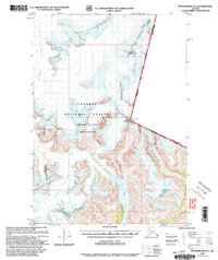
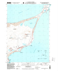 2001 Saint Paul Island East2002 Print · USGSSaint Paul Island in the Bering Sea is shown at the start of the millennium during a period of significant environmental restoration. Researchers can trace the intersection of maritime infrastructure and wildlife conservation at Northeast Point Rookery and the St Paul Island Airport.
 - 2001 Map of Saint Paul Island West, 2002 Print
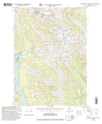
 2001 Saint Paul Island West2002 Print · USGSSaint Paul Island in the Pribilof chain appears at the start of the millennium, documenting the remote Bering Sea settlement and its surrounding rookeries. Trace the local landscape from the village of St Paul to landmarks like Telegraph Hill and Antone Lake.
Showing maps 1-25 of 33
Top cities of Alaska
- Anchorage historical maps
- Fairbanks historical maps
- Juneau historical maps
- Badger historical maps
- Wasilla historical maps
- Sitka historical maps
See more
Top boroughs of Alaska
Frequently asked questions
- What are the different types of historical maps available for Alaska?
- What is the oldest map of Alaska?
- Where can I purchase historical maps of Alaska for my home or office?
- Where can I download high-res historical maps of Alaska?
- Are there historical topographic maps available for Alaska?
- Is there historical aerial imagery available for Alaska?
- Where are historical maps of Alaska sourced from?