1960s Maps of Fairbanks North Star, Alaska
Explore 9 historic maps of Fairbanks North Star from the 1960s. These maps offer a rare glimpse into what life looked like during the 1960s — showing old roads, neighborhoods, homes, and landmarks that have changed or disappeared over time.
Whether you're researching your family's past, planning a metal detecting trip, or studying how Fairbanks North Star's landscape evolved across the 1960s, these high-resolution maps are a powerful tool for exploring the history of this region.
- Focus on a specific era: All maps on this page are from the 1960s, giving you a focused view of this time period.
- See what’s changed: Compare century-old streets, trails, and buildings to today's modern landscape using overlays and satellite layers.
- Research with precision: Use these maps for genealogy, historical research, land use analysis, or educational projects.
- View, download, or print: Maps are fully viewable online in high resolution, and can be downloaded or printed for your own records.
Start exploring Fairbanks North Star's history through authentic maps from the 1960s. This is your window into the past.
Fairbanks North Star, AK maps
(9)- 1964 Map of Fairbanks
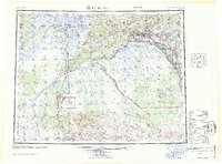 1964 Fairbanks1964 Print · USGSInterior Alaska in the mid-1960s centered on the growing hub of Fairbanks and its strategic military and rail connections. Genealogists and historians can trace the paths of The Alaska Railroad through Nenana or locate Placer Mines near Murphy Dome and Ester.
 - 1964 Map of Circle
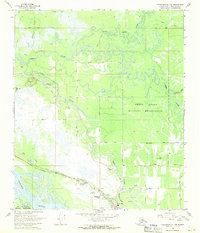
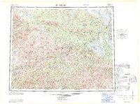 1964 Circle1964 Print · USGSThe Alaskan interior at the height of the mid-century wilderness era is defined here by the river-fed settlements and high mountain passes. Researchers can trace the path of the Steese Highway to Circle, finding remote sites like Circle Hot Springs and Miller House.
 - 1964 Map of Livengood
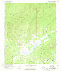
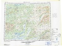 1964 Livengood1964 Print · USGSInterior Alaska during the mid-sixties shows a land shaped by the gold mining industry and new road networks. Researchers can trace the path of the Davidson Ditch and locate historic mining camps such as Pedro Camp, Chatanika, and Golden City.
 - 1965 Map of Fairbanks D-2, 1966 Print
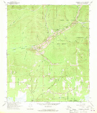
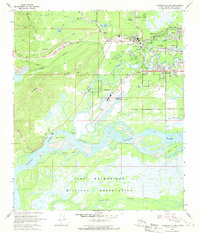
 1965 Fairbanks D-21966 Print · USGSMid-century Fairbanks and its growing suburbs are captured here as the interior infrastructure of Alaska modernized. Genealogists and historians can trace the early footprints of College, Dogpatch, and Fort Wainwright alongside the sprawling TANANA RIVER.
 - 1966 Map of Fairbanks D-2 NE, 1970 Print
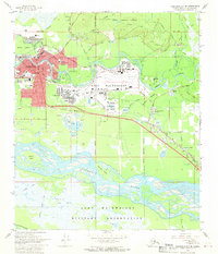
 1966 Fairbanks D-2 NE1970 Print · USGSThe Fairbanks interior during the mid-sixties reveals a landscape defined by mining industry and emerging satellite technology. You can trace the Dredge Tailings along the creeks, locate the Tungsten Hill Mine, and see the footprint of the Gilmore Data Acquisition Facility.2 unique versions available
 - 1966 Map of Fairbanks D-2 SW, 1970 Print
 1966 Fairbanks D-2 SW1970 Print · USGSFairbanks and its surrounding river valleys come alive in the mid-sixties as the university and military base expand. Trace the industrial landscape of Dredge Tailings and the Alaska Railroad alongside settlements at College and Ester Crossing.2 unique versions available
 - 1966 Map of Fairbanks D-2 SE, 1970 Print
 1966 Fairbanks D-2 SE1970 Print · USGSFairbanks and the sprawling Fort Wainwright complex are shown here in the mid-1960s as the Interior hub expanded. Researchers can trace the development of Lemeta, locate early schools like Main Sch, and follow the Alaska Railroad through the city.2 unique versions available
 - 1966 Map of Fairbanks D-1 SW, 1970 Print
 1966 Fairbanks D-1 SW1970 Print · USGSThe Fairbanks area in the mid-sixties reveals a landscape defined by meandering rivers and growing military and civilian infrastructure. Local historians can trace early developments at North Pole and Highland Park or locate aviation landmarks like the Bradley Sky Ranch.2 unique versions available
 - 1966 Map of Fairbanks D-2 NW, 1970 Print
 1966 Fairbanks D-2 NW1970 Print · USGSThe Fairbanks outskirts in the mid-1960s show a landscape of mining history and developing infrastructure along The Alaska Railroad. Researchers can locate vanished infrastructure like the Goldstream Airfield and trace settlements at Musk Ox and Dogpatch.2 unique versions available
End of results
Showing maps 1-9 of 9
Top cities of Fairbanks North Star
Frequently asked questions
- What are the different types of historical maps available for Fairbanks North Star?
- What is the oldest map of Fairbanks North Star?
- Where can I purchase historical maps of Fairbanks North Star for my home or office?
- Where can I download high-res historical maps of Fairbanks North Star?
- Are there historical topographic maps available for Fairbanks North Star?
- Is there historical aerial imagery available for Fairbanks North Star?
- Where are historical maps of Fairbanks North Star sourced from?