1940s Maps of Fairbanks North Star, Alaska
Explore 11 historic maps of Fairbanks North Star from the 1940s. These maps offer a rare glimpse into what life looked like during the 1940s — showing old roads, neighborhoods, homes, and landmarks that have changed or disappeared over time.
Whether you're researching your family's past, planning a metal detecting trip, or studying how Fairbanks North Star's landscape evolved across the 1940s, these high-resolution maps are a powerful tool for exploring the history of this region.
- Focus on a specific era: All maps on this page are from the 1940s, giving you a focused view of this time period.
- See what’s changed: Compare century-old streets, trails, and buildings to today's modern landscape using overlays and satellite layers.
- Research with precision: Use these maps for genealogy, historical research, land use analysis, or educational projects.
- View, download, or print: Maps are fully viewable online in high resolution, and can be downloaded or printed for your own records.
Start exploring Fairbanks North Star's history through authentic maps from the 1940s. This is your window into the past.
Fairbanks North Star, AK maps
(11)- 1945 Map of Livengood
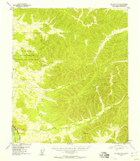
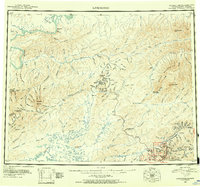 1945 Livengood1945 Print · USGSThe Alaska Interior at the end of World War II reveals a landscape of mining camps and river outposts. Trace the early road network from Chatanika to the gold fields of Livengood, or locate the site of Fort Hamlin.4 unique versions available
 - 1949 Map of Fairbanks D-1
 1949 Fairbanks D-11949 Print · USGSInterior Alaska at the close of the 1940s reveals a landscape defined by gold-stream drainages and the early road network south of the hills. Trace the winding Chena Slough and the tracks of the Alaska Railroad as they parallel the Richardson Highway.7 unique versions available
 - 1949 Map of Fairbanks D-2
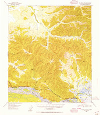
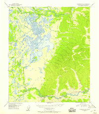
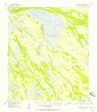
 1949 Fairbanks D-21949 Print · USGSFairbanks and the surrounding Tanana Valley are captured here just after the war years as the region's military and academic infrastructure expanded. Genealogy researchers and local historians can trace the early layout of the Univ of Alaska, the grounds of Ladd Field, and the outlying settlement at Ester.
 - 1949 Map of Big Delta B-5, 1955 Print
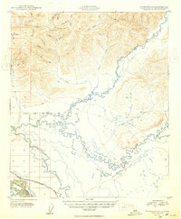
 1949 Big Delta B-51955 Print · USGSThe Tanana River valley and the Richardson Highway corridor are shown in the late 1940s as interior Alaska developed. Genealogists and historians can trace isolated landmarks like Richardson, Shaw Creek Lodge, and the J Fowler Cabin.3 unique versions available
 - 1949 Map of Big Delta B-6, 1956 Print
 1949 Big Delta B-61956 Print · USGSThe Alaskan interior during the early Cold War era is defined here by the massive footprint of the Ladd Air Force Base Bombing and Gunnery Range. You can trace historical travel routes along the Richardson Highway, stopping at landmarks like Aurora Lodge and the Military Rest Camp (Aban'd) at Birch Lake.6 unique versions available
 - 1949 Map of Fairbanks C-1, 1958 Print
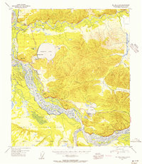
 1949 Fairbanks C-11958 Print · USGSDuring the early Cold War, this Alaska territory was defined by massive military installations and the braided Tanana River. Trace the early footprint of Eielson Air Force Base and the legacy transport corridor of the Alaska Railroad.
 - 1949 Map of Fairbanks D-3, 1958 Print
 1949 Fairbanks D-31958 Print · USGSThe Alaska interior at the end of the 1940s reveals a landscape defined by the Alaska Railroad and early industrial access. Researchers can trace the path of the Sled Road, find the location of Old Saulich, or locate remote Cabins tucked along Goldstream Creek.
 - 1949 Map of Big Delta C-6, 1958 Print
 1949 Big Delta C-61958 Print · USGSInterior Alaska in the late 1940s was a landscape of military growth and river corridors. Researchers can trace the early footprint of Eielson Air Force Base and the path of the Richardson Highway alongside the Tanana River.6 unique versions available
 - 1949 Map of Fairbanks D-4, 1958 Print
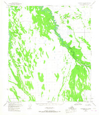
 1949 Fairbanks D-41958 Print · USGSThe interior Alaska wilderness north of Fairbanks comes into focus in the late 1940s, showing a land defined by rail and water. Researchers can trace the path of The Alaska Railroad past Dunbar and find the site of an Indian Cemetery near the Minto Lakes.5 unique versions available
 - 1949 Map of Fairbanks C-2, 1958 Print
 1949 Fairbanks C-21958 Print · USGSThe Tanana Valley interior reveals its Cold War military footprint in the late 1940s. Researchers can trace the vast Ladd Air Force Base, the Bombing and Gunnery Range, and landmarks like Bonnifield Clear Creek Butte.3 unique versions available
 - 1949 Map of Fairbanks B-3, 1967 Print
 1949 Fairbanks B-31967 Print · USGSThe roadless interior of Alaska south of Fairbanks is revealed here during the late 1940s, a period of expanding military land use. Researchers can trace the winding Wood River or locate remote drainage points like Bonnifield Gold King Creek and Blair Lake.3 unique versions available
End of results
Showing maps 1-11 of 11
Top cities of Fairbanks North Star
Frequently asked questions
- What are the different types of historical maps available for Fairbanks North Star?
- What is the oldest map of Fairbanks North Star?
- Where can I purchase historical maps of Fairbanks North Star for my home or office?
- Where can I download high-res historical maps of Fairbanks North Star?
- Are there historical topographic maps available for Fairbanks North Star?
- Is there historical aerial imagery available for Fairbanks North Star?
- Where are historical maps of Fairbanks North Star sourced from?