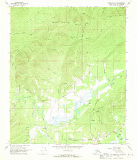
1966 Map of Fairbanks D-2 NW
USGS Topo · Published 1970About this map
Murphy Dome anchors the high ground of the northern interior, overlooking a landscape defined by the intersection of aviation, mining, and the rail industry. The lowlands are marked by Goldstream Creek and the extensive Dredge Tailings that signal the area's rich prospecting history. Transportation networks are central to this 1960s landscape, featuring The Alaska Railroad and the Old Railroad Grade winding through the valley floor. Small clusters of settlement like Musk Ox, Dogpatch, and Happy appear alongside local landmarks such as Goldstream Airfield and the Fairbanks Country Club. The northern portion of the map is dominated by a large Military Reservation, while family and local history is anchored at the Northern Lights Memorial Cem. This survey illustrates the transition from resource extraction to established community infrastructure outside of the main city center.
Find a feature on this map
57 named features on this map. Tap any name to fly to it.
Don’t see what you’re looking for? This feature index may not catch every label — zoom into the map to look around manually.
Map Details
Editions of this 1966 Fairbanks D-2 NW Map
2 editions found
Other maps of this area

1945 · Livengood
USGS Topo · 1:250,000

1949 · Fairbanks D-2
USGS Topo · 1:62,500

1949 · Fairbanks D-3
USGS Topo · 1:63,360

1950 · Fairbanks
USGS Topo · 1:250,000

1950 · Fairbanks D-3
USGS Topo · 1:63,360

1951 · Fairbanks
USGS Topo · 1:250,000

1951 · Livengood
USGS Topo · 1:250,000

1952 · Fairbanks D-2
USGS Topo · 1:63,360

1952 · Fairbanks D-3
USGS Topo · 1:63,360

1952 · Fairbanks
USGS Topo · 1:250,000