1990s Maps of Excursion Inlet, Alaska
Explore 1 historic maps of Excursion Inlet from the 1990s. These maps offer a rare glimpse into what life looked like during the 1990s — showing old roads, neighborhoods, homes, and landmarks that have changed or disappeared over time.
Whether you're researching your family's past, planning a metal detecting trip, or studying how Excursion Inlet's landscape evolved across the 1990s, these high-resolution maps are a powerful tool for exploring the history of this region.
- Focus on a specific era: All maps on this page are from the 1990s, giving you a focused view of this time period.
- See what’s changed: Compare century-old streets, trails, and buildings to today's modern landscape using overlays and satellite layers.
- Research with precision: Use these maps for genealogy, historical research, land use analysis, or educational projects.
- View, download, or print: Maps are fully viewable online in high resolution, and can be downloaded or printed for your own records.
Start exploring Excursion Inlet's history through authentic maps from the 1990s. This is your window into the past.
Excursion Inlet, AK maps
(1)- 1996 Map of Juneau B-4, 2000 Print
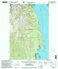 1996 Juneau B-42000 Print · USGSCoastal wilderness and the heights of the Chilkat Range are documented in the late nineties as they border the City and Borough of Juneau. Trace the intersection of Glacier Bay National Park and the Tongass National Forest along Lynn Canal.
End of results
Showing maps 1-1 of 1
Top cities near Excursion Inlet
Frequently asked questions
- What are the different types of historical maps available for Excursion Inlet?
- What is the oldest map of Excursion Inlet?
- Where can I purchase historical maps of Excursion Inlet for my home or office?
- Where can I download high-res historical maps of Excursion Inlet?
- Are there historical topographic maps available for Excursion Inlet?
- Is there historical aerial imagery available for Excursion Inlet?
- Where are historical maps of Excursion Inlet sourced from?