1950s Maps of Pilot Point, Alaska
Explore 4 historic maps of Pilot Point from the 1950s. These maps offer a rare glimpse into what life looked like during the 1950s — showing old roads, neighborhoods, homes, and landmarks that have changed or disappeared over time.
Whether you're researching your family's past, planning a metal detecting trip, or studying how Pilot Point's landscape evolved across the 1950s, these high-resolution maps are a powerful tool for exploring the history of this region.
- Focus on a specific era: All maps on this page are from the 1950s, giving you a focused view of this time period.
- See what’s changed: Compare century-old streets, trails, and buildings to today's modern landscape using overlays and satellite layers.
- Research with precision: Use these maps for genealogy, historical research, land use analysis, or educational projects.
- View, download, or print: Maps are fully viewable online in high resolution, and can be downloaded or printed for your own records.
Start exploring Pilot Point's history through authentic maps from the 1950s. This is your window into the past.
Pilot Point, AK maps
(4)- 1951 Map of Bristol Bay
 1951 Bristol Bay1951 Print · USGSBristol Bay and the western edge of the Alaska Peninsula are captured here in the early 1950s, based on earlier reconnaissance and aerial photography. Researchers can trace the shifting coastal geometry of the Tidal Flats and the courses of Cinder River and Reindeer Creek.
 - 1951 Map of Ugashik C-5, 1956 Print
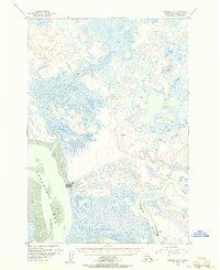 1951 Ugashik C-51956 Print · USGSThe Alaska Peninsula coastline comes into focus in the early 1950s, documenting the vital fishing outposts of the Bristol Bay region. Researchers can trace the layout of Pilot Point and find industrial landmarks like the Cannery and Water Towers near Ugashik Bay.2 unique versions available
 - 1951 Map of Ugashik C-6, 1956 Print
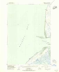 1951 Ugashik C-61956 Print · USGSThe Alaska Peninsula coastline appears in the early fifties, defined by the vast waters where Bristol Bay meets the mainland. Map collectors and researchers can trace isolated shoreline structures like the Cabins near Cape Menshikof and the Smoky Point Light.2 unique versions available
 - 1954 Map of Ugashik B-5, 1968 Print
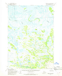 1954 Ugashik B-51968 Print · USGSThe Alaska Peninsula coast in the mid-fifties shows a vast network of tundra rivers and tidewater flats. Researchers can trace the meandering paths of the King Salmon River and Dog Salmon River near the isolated settlement at Dennis.2 unique versions available
End of results
Showing maps 1-4 of 4
Frequently asked questions
- What are the different types of historical maps available for Pilot Point?
- What is the oldest map of Pilot Point?
- Where can I purchase historical maps of Pilot Point for my home or office?
- Where can I download high-res historical maps of Pilot Point?
- Are there historical topographic maps available for Pilot Point?
- Is there historical aerial imagery available for Pilot Point?
- Where are historical maps of Pilot Point sourced from?