1960s Maps of Pilot Point, Alaska
Explore 5 historic maps of Pilot Point from the 1960s. These maps offer a rare glimpse into what life looked like during the 1960s — showing old roads, neighborhoods, homes, and landmarks that have changed or disappeared over time.
Whether you're researching your family's past, planning a metal detecting trip, or studying how Pilot Point's landscape evolved across the 1960s, these high-resolution maps are a powerful tool for exploring the history of this region.
- Focus on a specific era: All maps on this page are from the 1960s, giving you a focused view of this time period.
- See what’s changed: Compare century-old streets, trails, and buildings to today's modern landscape using overlays and satellite layers.
- Research with precision: Use these maps for genealogy, historical research, land use analysis, or educational projects.
- View, download, or print: Maps are fully viewable online in high resolution, and can be downloaded or printed for your own records.
Start exploring Pilot Point's history through authentic maps from the 1960s. This is your window into the past.
Pilot Point, AK maps
(5)- 1963 Map of Ugashik B-6, 1967 Print
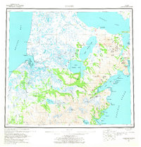
 1963 Ugashik B-61967 Print · USGSThe Bristol Bay coastline in the early sixties remains a wilderness of shifting tides and river networks. Researchers can trace the paths of the King Salmon River and Cynder River or locate a solitary Cabin along the remote banks.2 unique versions available
 - 1963 Map of Bristol Bay, 1967 Print
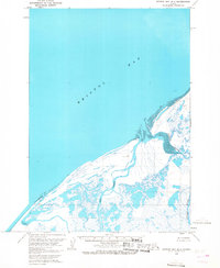
 1963 Bristol Bay1967 Print · USGSThe Alaska Peninsula coastline at Bristol Bay is captured here in the early sixties, showing a landscape of coastal marshes and isolated outposts. Trace the locations of Sherry, Alfred, and Hook Lagoon along the banks of the Cinder River and Mud Creek.3 unique versions available
 - 1963 Map of Bristol Bay B-1, 1968 Print
 1963 Bristol Bay B-11968 Print · USGSThe remote Alaska Peninsula coastline comes into focus during the early sixties, showing a landscape defined by seasonal camps and winding deltas. Genealogists and historians can locate isolated points like Edith, Tugg, and Roost along the Cinder River.2 unique versions available
 - 1963 Map of Ugashik, 1968 Print
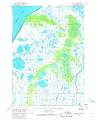
 1963 Ugashik1968 Print · USGSThe Alaska Peninsula in the early sixties reveals a wild coastal landscape of volcanic peaks and isolated maritime settlements. Researchers can trace the layout of Pilot Point and Ugashik or locate landmarks like Greig Light and Mount Peulik.3 unique versions available
 - 1967 Map of Bristol Bay
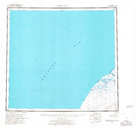
 1967 Bristol Bay1967 Print · USGSBristol Bay and the Alaska Peninsula coast are captured here in the late sixties, a period of remote maritime surveying. Researchers can trace isolated coastal markers and geography like Hook Lagoon, Cinder River, and the Tidal Flat near Tugg.
End of results
Showing maps 1-5 of 5
Frequently asked questions
- What are the different types of historical maps available for Pilot Point?
- What is the oldest map of Pilot Point?
- Where can I purchase historical maps of Pilot Point for my home or office?
- Where can I download high-res historical maps of Pilot Point?
- Are there historical topographic maps available for Pilot Point?
- Is there historical aerial imagery available for Pilot Point?
- Where are historical maps of Pilot Point sourced from?