
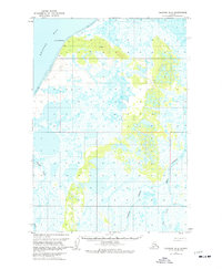
1963 Map of Ugashik B-6
USGS Topo · Published 1967About this map
Cape Menshikof overlooks the expansive Bristol Bay shoreline, where a vast Tidal Flat marks the transition between the Bering Sea and the Alaskan interior. The landscape is defined by an intricate network of waterways, most notably the King Salmon River and the meandering Cynder River, which cut through low-lying marshlands. This 1963 field-annotated survey reveals a region largely untouched by formal infrastructure, characterized instead by water and terrain. Interior hydrology is dominated by the Pumice Creek and the small Old Creek drainage. Human activity is sparse, indicated only by a lone Cabin near the riverbanks, suggesting a landscape primarily used for seasonal subsistence or trapping during the mid-20th century. The mapping of this quadrangle relied heavily on photogrammetric methods from 1957 aerial photography, capturing the shifting drainage patterns of the Bristol Bay coast.
Find a feature on this map
19 named features on this map. Tap any name to fly to it.
Don’t see what you’re looking for? This feature index may not catch every label — zoom into the map to look around manually.
Map Details
Editions of this 1963 Ugashik B-6 Map
2 editions found
Other maps of this area

1943 · Ugashik
USGS Topo · 1:250,000

1948 · Ugashik
USGS Topo · 1:250,000

1949 · Ugashik
USGS Topo · 1:250,000

1951 · Bristol Bay
USGS Topo · 1:250,000

1951 · Ugashik C-5
USGS Topo · 1:63,360

1951 · Ugashik C-6
USGS Topo · 1:63,360

1954 · Ugashik B-5
USGS Topo · 1:63,360

1963 · Ugashik A-6
USGS Topo · 1:63,360

1963 · Bristol Bay
USGS Topo · 1:250,000

1963 · Bristol Bay A-1
USGS Topo · 1:63,360