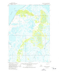
1963 Map of Ugashik B-6
USGS Topo · Published 1977About this map
Cape Menshikof defines the northwest corner of this coastal landscape, where the waters of Bristol Bay meet the shoreline of the Alaska Peninsula. The interior is a complex network of wetlands and drainage systems, dominated by the Cinder River and Pumice Creek flowing through an area of low relief and numerous unnamed ponds. Small, isolated points of human activity are noted by simple labels such as John, Pete, Bert, and Alra, which likely represent seasonal camps or small homesteads in this remote region. A solitary Landing Strip and a simple Cabin further south underscore the area's reliance on bush aviation and subsistence living. The map also delineates the extensive Tidal Flats along the coast and the course of King Salmon Creek, reflecting a wilderness environment where waterways serve as the primary landmarks and transit corridors.
Find a feature on this map
14 named features on this map. Tap any name to fly to it.
Don’t see what you’re looking for? This feature index may not catch every label — zoom into the map to look around manually.
Map Details
Editions of this 1963 Ugashik B-6 Map
2 editions found
Other maps of this area

1943 · Ugashik
USGS Topo · 1:250,000

1948 · Ugashik
USGS Topo · 1:250,000

1949 · Ugashik
USGS Topo · 1:250,000

1951 · Bristol Bay
USGS Topo · 1:250,000

1951 · Ugashik C-5
USGS Topo · 1:63,360

1951 · Ugashik C-6
USGS Topo · 1:63,360

1954 · Ugashik B-5
USGS Topo · 1:63,360

1963 · Ugashik B-6
USGS Topo · 1:63,360

1963 · Ugashik A-6
USGS Topo · 1:63,360

1963 · Bristol Bay
USGS Topo · 1:250,000