
1951 Map of Ugashik C-6
USGS Topo · Published 1956About this map
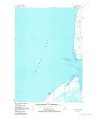
Bristol Bay and the entrance to Ugashik Bay dominate this 1951 survey, capturing a shoreline defined by shifting waters and immense tidal zones. The map focuses on the eastern coast of the Bering Sea, where the land transitions into expansive Tidal Flats at Cape Menshikof and Cape Greig. Isolated structures, simply labeled Cabin and Cabins, are the only evidence of human habitation along this remote stretch of the Alaska Peninsula, likely used by seasonal fishermen or trappers. Navigation along the treacherous coast is marked by the Smoky Point Light at Smoky Pt. The reliance on aerial photography and earlier hydrographic charts highlights the difficulty of surveying this coastal environment during the early 1950s.
Find a feature on this map
14 named features on this map. Tap any name to fly to it.
Don’t see what you’re looking for? This feature index may not catch every label — zoom into the map to look around manually.
Map Details
Editions of this 1951 Ugashik C-6 Map
2 editions found
Other maps of this area

1943 · Ugashik
USGS Topo · 1:250,000

1948 · Ugashik
USGS Topo · 1:250,000

1949 · Ugashik
USGS Topo · 1:250,000

1951 · Bristol Bay
USGS Topo · 1:250,000

1951 · Ugashik C-5
USGS Topo · 1:63,360

1951 · Ugashik D-5 and D-6
USGS Topo · 1:63,360

1954 · Ugashik B-5
USGS Topo · 1:63,360

1963 · Ugashik B-6
USGS Topo · 1:63,360

1963 · Bristol Bay
USGS Topo · 1:250,000
1963 · Bristol Bay B-1
USGS Topo · 1:63,360