
1951 Map of Ugashik D-5 and D-6
USGS Topo · Published 1956About this map
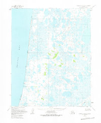
Bristol Bay dominates the western edge of this coastal survey, where the interface of land and sea is defined by a broad Tidal Flat. The landscape is a complex mosaic of countless small ponds and wetlands typical of the Alaska Peninsula. Moving inland, the Ugashik River and Dodo Creek provide the primary drainage for this water-saturated terrain. Small signs of human presence appear as an isolated Cabin and several vertical angle bench marks (VABMs), which served as critical survey points for the Geological Survey during the early 1950s. These markers, such as VABM 198 Vivien and VABM 204 Rusty, suggest the specialized nature of the mapping parties working in this subarctic environment before modern satellite imagery.
Find a feature on this map
14 named features on this map. Tap any name to fly to it.
Don’t see what you’re looking for? This feature index may not catch every label — zoom into the map to look around manually.
Map Details
Editions of this 1951 Ugashik D-5 and D-6 Map
2 editions found
Other maps of this area

1943 · Ugashik
USGS Topo · 1:250,000

1948 · Ugashik
USGS Topo · 1:250,000

1949 · Ugashik
USGS Topo · 1:250,000

1951 · Ugashik C-5
USGS Topo · 1:63,360

1951 · Ugashik C-4
USGS Topo · 1:63,360

1951 · Ugashik D-4
USGS Topo · 1:63,360

1951 · Naknek A-5
USGS Topo · 1:63,360

1951 · Naknek A-4
USGS Topo · 1:63,360

1951 · Ugashik C-6
USGS Topo · 1:63,360

1952 · Naknek
USGS Topo · 1:250,000