
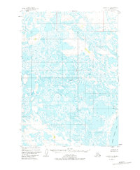
1951 Map of Ugashik C-4
USGS Topo · Published 1956About this map
The Ugashik River meanders across this subarctic landscape, carving a complex path through a dense network of countless small ponds and wetlands. This 1951 aerial survey depicts a region defined by its water, where the massive Lower Ugashik Lake dominates the southeastern corner. Signs of human presence are sparse and functional, centered primarily on the river system. A lonely Cabin stands along a northern bend, while further downstream near the lake, a cluster of Cabins and a Footbridge suggest a seasonal base for trapping or fishing. The intricate drainage patterns and lack of established roads highlight the isolation of the Alaska Peninsula during the mid-twentieth century, showing a terrain where travel was dictated entirely by the waterways and the shifting marshes between them.
Find a feature on this map
5 named features on this map. Tap any name to fly to it.
Don’t see what you’re looking for? This feature index may not catch every label — zoom into the map to look around manually.
Map Details
Editions of this 1951 Ugashik C-4 Map
2 editions found
Other maps of this area

1943 · Ugashik
USGS Topo · 1:250,000

1948 · Ugashik
USGS Topo · 1:250,000

1949 · Ugashik
USGS Topo · 1:250,000

1951 · Ugashik C-5
USGS Topo · 1:63,360

1951 · Ugashik B-3
USGS Topo · 1:63,360

1951 · Ugashik D-5 and D-6
USGS Topo · 1:63,360

1951 · Ugashik D-3
USGS Topo · 1:63,360

1951 · Ugashik D-4
USGS Topo · 1:63,360

1951 · Ugashik C-3
USGS Topo · 1:63,360

1954 · Ugashik B-4
USGS Topo · 1:63,360