
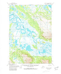
1954 Map of Ugashik B-4
USGS Topo · Published 1968About this map
Dog Salmon River meanders across this vast alluvial plain on the Alaska Peninsula, showcasing a complex network of oxbow lakes, abandoned channels, and seasonal wetlands. The 1954 fieldwork captures the wild character of the landscape before significant modern changes, dominated by the sluggish water of the Lower Ugashik Lake in the northeast corner. Higher elevations rise toward the southeast, where survey stations like Salmon 1222 and Chig 2006 provide vertical control points amidst the tundra. This map is a record of the intricate hydrological patterns of the Bristol Bay region, illustrating how the river systems define the geography of the Lake and Peninsula area.
Find a feature on this map
4 named features on this map. Tap any name to fly to it.
Don’t see what you’re looking for? This feature index may not catch every label — zoom into the map to look around manually.
Map Details
Editions of this 1954 Ugashik B-4 Map
2 editions found
Other maps of this area

1943 · Ugashik
USGS Topo · 1:250,000

1948 · Ugashik
USGS Topo · 1:250,000

1949 · Ugashik
USGS Topo · 1:250,000

1951 · Ugashik C-5
USGS Topo · 1:63,360

1951 · Ugashik C-4
USGS Topo · 1:63,360

1951 · Ugashik B-3
USGS Topo · 1:63,360

1951 · Ugashik C-3
USGS Topo · 1:63,360

1954 · Ugashik A-3
USGS Topo · 1:63,360

1954 · Ugashik B-5
USGS Topo · 1:63,360

1963 · Ugashik A-4
USGS Topo · 1:63,360