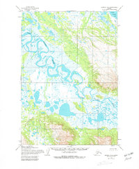
1954 Map of Ugashik B-4
USGS Topo · Published 1981About this map
Dog Salmon River meanders across this vast alluvial plain, tracing an intricate course through the wetlands of the Alaska Peninsula. Compiled from aerial photographs taken between 1951 and 1953, the map depicts a landscape dominated by complex hydrological patterns where the river intersects with numerous unnamed ponds and tundra marshes. In the northeast corner, the southern reaches of Lower Ugashik Lake provide a rare fixed landmark in a territory defined by shifting seasonal waters. The topography reflects a period of extensive surveying by the Army Map Service and the Bureau of Land Management, capturing the raw state of this wilderness before significant modern infrastructure. The lack of named settlements or man-made structures emphasizes the isolation of the region, where the primary geographical features are the serpentine waterways and the low-lying terrain they carve.
Find a feature on this map
2 named features on this map. Tap any name to fly to it.
Don’t see what you’re looking for? This feature index may not catch every label — zoom into the map to look around manually.
Map Details
Editions of this 1954 Ugashik B-4 Map
2 editions found
Other maps of this area

1943 · Ugashik
USGS Topo · 1:250,000

1948 · Ugashik
USGS Topo · 1:250,000

1949 · Ugashik
USGS Topo · 1:250,000

1951 · Ugashik C-5
USGS Topo · 1:63,360

1951 · Ugashik C-4
USGS Topo · 1:63,360

1951 · Ugashik B-3
USGS Topo · 1:63,360

1951 · Ugashik C-3
USGS Topo · 1:63,360

1954 · Ugashik A-3
USGS Topo · 1:63,360

1954 · Ugashik B-4
USGS Topo · 1:63,360

1954 · Ugashik B-5
USGS Topo · 1:63,360