
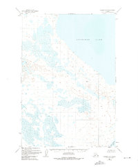
1951 Map of Ugashik D-3
USGS Topo · Published 1956About this map
The massive shoreline of Becharof Lake dominates this 1951 aerial study of the Alaska Peninsula, showcasing a landscape defined by expansive wetlands and glacial hydrology. This remote coastal interior, captured by the Geological Survey during a period of intensive post-war topographic mapping, reveals a complex network of marshes and small kettle ponds that fill the lowlands between the larger bodies of water. In the southeastern corner of the quadrangle, the map captures a portion of Upper Ugashik Lake, while the higher ground is marked by survey points such as VABM 243 Rost. The absence of roads or established settlements emphasizes the wilderness character of the Third Judicial Division at mid-century, where topography was recorded using multiplex methods from aerial photography to document the intricate drainage patterns of the tundra.
Find a feature on this map
3 named features on this map. Tap any name to fly to it.
Don’t see what you’re looking for? This feature index may not catch every label — zoom into the map to look around manually.
Map Details
Editions of this 1951 Ugashik D-3 Map
2 editions found
Other maps of this area

1943 · Ugashik
USGS Topo · 1:250,000

1948 · Ugashik
USGS Topo · 1:250,000

1949 · Ugashik
USGS Topo · 1:250,000

1951 · Ugashik C-4
USGS Topo · 1:63,360

1951 · Ugashik C-2
USGS Topo · 1:63,360

1951 · Naknek A-2
USGS Topo · 1:63,360

1951 · Ugashik D-4
USGS Topo · 1:63,360

1951 · Naknek A-4
USGS Topo · 1:63,360

1951 · Ugashik C-3
USGS Topo · 1:63,360

1951 · Ugashik D-2
USGS Topo · 1:63,360