
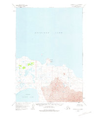
1951 Map of Ugashik D-2
USGS Topo · Published 1956About this map
Becharof Lake dominates the northern half of this mid-century topographic study, which captures the remote volcanic landscape between the Great Lake and Upper Ugashik Lake to the south. The terrain is defined by extensive fields of Lava that flow toward the shoreline, culminating in the prominent peak of Mt Peulik in the southeast corner. Along the southern edge of Becharof Lake, distinctive geological features like The Gas Rocks and VABM Gas Rocks mark the transition from the water to the rugged interior. Human presence is minimal in this wilderness, recorded only by isolated Cabin sites near the lake margins. These remote outposts and the lack of established roads reflect the area's isolation during the early 1950s, when mapping relied heavily on aerial photographs before field checking could be completed.
Find a feature on this map
7 named features on this map. Tap any name to fly to it.
Don’t see what you’re looking for? This feature index may not catch every label — zoom into the map to look around manually.
Map Details
Editions of this 1951 Ugashik D-2 Map
2 editions found
Other maps of this area

1943 · Ugashik
USGS Topo · 1:250,000

1948 · Ugashik
USGS Topo · 1:250,000

1949 · Ugashik
USGS Topo · 1:250,000

1951 · Ugashik D-1
USGS Topo · 1:63,360

1951 · Ugashik C-1
USGS Topo · 1:63,360

1951 · Ugashik C-2
USGS Topo · 1:63,360

1951 · Ugashik D-3
USGS Topo · 1:63,360

1951 · Naknek A-2
USGS Topo · 1:63,360

1951 · Naknek A-1
USGS Topo · 1:63,360

1951 · Ugashik C-3
USGS Topo · 1:63,360