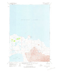
1951 Map of Ugashik D-2
USGS Topo · Published 1974About this map
Becharof Lake dominates the northern landscape of this Alaska Peninsula survey, providing a stark contrast to the volcanic activity recorded to the south. Along the southern shore, The Gas Rocks and the triangulation point at Vabm 431 Gas Rocks mark a geologically active transition toward the massif of Mt Peulik. Extensive fields of Lava are mapped in detail, flowing from the volcanic heights toward the basin of Upper Ugashik Lake. This early 1950s documentation shows the area in a nearly untouched state, with only a solitary Cabin noted as a sign of human presence in the vast stretch between the two major lakes. The topography reflects a raw, post-glacial environment where drainage patterns and volcanic deposits were the primary focus of the Bureau of Land Management and Geological Survey teams.
Find a feature on this map
7 named features on this map. Tap any name to fly to it.
Don’t see what you’re looking for? This feature index may not catch every label — zoom into the map to look around manually.
Map Details
Editions of this 1951 Ugashik D-2 Map
2 editions found

Other maps of this area

1943 · Ugashik
USGS Topo · 1:250,000

1948 · Ugashik
USGS Topo · 1:250,000

1949 · Ugashik
USGS Topo · 1:250,000

1951 · Ugashik D-1
USGS Topo · 1:63,360

1951 · Ugashik C-1
USGS Topo · 1:63,360

1951 · Ugashik C-2
USGS Topo · 1:63,360

1951 · Ugashik D-3
USGS Topo · 1:63,360

1951 · Naknek A-2
USGS Topo · 1:63,360

1951 · Naknek A-1
USGS Topo · 1:63,360

1951 · Ugashik C-3
USGS Topo · 1:63,360