
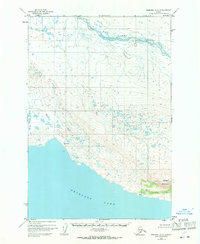
1951 Map of Naknek A-2
USGS Topo · Published 1956About this map
Becharof Lake defines the southern expanse of this Alaskan landscape, captured during a 1951 aerial survey. The northern edge is dominated by the meandering course of the King Salmon River, which snakes across the tundra before the terrain rises into the complex drainage systems of the interior. A single Cabin along the shoreline of Becharof Lake provides a rare sign of human presence in this wilderness, offering a specific point of interest for those researching early regional trails or bush shelters. High points across the varying elevations are marked by surveying benchmarks, including VABM 184 Jeanne and VABM 335 Blue, which were essential for mapping this territory. The hydrology of the area is further detailed by the path of Shosky Creek, which flows through the breaks toward the coast.
Find a feature on this map
6 named features on this map. Tap any name to fly to it.
Don’t see what you’re looking for? This feature index may not catch every label — zoom into the map to look around manually.
Map Details
Editions of this 1951 Naknek A-2 Map
2 editions found
Other maps of this area

1943 · Ugashik
USGS Topo · 1:250,000

1948 · Ugashik
USGS Topo · 1:250,000

1949 · Ugashik
USGS Topo · 1:250,000

1951 · Ugashik D-1
USGS Topo · 1:63,360

1951 · Naknek B-1
USGS Topo · 1:63,360

1951 · Ugashik D-3
USGS Topo · 1:63,360

1951 · Naknek A-1
USGS Topo · 1:63,360

1951 · Ugashik D-2
USGS Topo · 1:63,360

1951 · Naknek A-3
USGS Topo · 1:63,360

1952 · Naknek
USGS Topo · 1:250,000