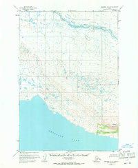
1951 Map of Naknek A-2
USGS Topo · Published 1971About this map
Becharof Lake dominates the southern landscape of this 1951 photogrammetric survey, its expansive shoreline meeting a complex network of marshes and small ponds. Further north, the King Salmon River meanders across the tundra, defining the drainage patterns of this remote Alaska Peninsula region. The terrain is marked by significant elevations such as Whale Mountain and various survey points including VABM Blue 335 and VABM Jeanne 184. Human presence is minimal, noted only by a lone Cabin near the lake's edge. The map captures the raw geographical character of the area prior to significant 20th-century development, focusing on the intricate waterways of Shosky Creek and the vast, unpeopled stretches between the river systems and the mountain ridges.
Find a feature on this map
7 named features on this map. Tap any name to fly to it.
Don’t see what you’re looking for? This feature index may not catch every label — zoom into the map to look around manually.
Map Details
Editions of this 1951 Naknek A-2 Map
2 editions found
Other maps of this area

1943 · Ugashik
USGS Topo · 1:250,000

1948 · Ugashik
USGS Topo · 1:250,000

1949 · Ugashik
USGS Topo · 1:250,000

1951 · Ugashik D-1
USGS Topo · 1:63,360

1951 · Naknek B-1
USGS Topo · 1:63,360

1951 · Ugashik D-3
USGS Topo · 1:63,360

1951 · Naknek A-2
USGS Topo · 1:63,360

1951 · Naknek A-1
USGS Topo · 1:63,360

1951 · Ugashik D-2
USGS Topo · 1:63,360

1951 · Naknek A-3
USGS Topo · 1:63,360