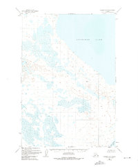
1951 Map of Ugashik D-3
USGS Topo · Published 1975About this map
Becharof Lake dominates this 1951 aerial study of the Alaska Peninsula, where a complex network of wetlands and tundra ponds defines the shoreline. The mapping reflects a landscape shaped by glacial retreat and hydrological shifts, showing the vast expanse of water that characterizes the region between the North Pacific and the Bering Sea. In the south, the terrain begins to rise toward Upper Ugashik Lake, providing a distinct transition from the low-lying coastal marshes to the elevated interior. A single named triangulation point, VABM 243 Rost, serves as a rare vertical benchmark in an area primarily defined by its horizontal watery expanse. This survey, conducted shortly after the war using photogrammetric methods, captures the intricate and largely uninhabited drainage patterns before modern environmental changes altered these sensitive subarctic ecosystems.
Find a feature on this map
3 named features on this map. Tap any name to fly to it.
Don’t see what you’re looking for? This feature index may not catch every label — zoom into the map to look around manually.
Map Details
Editions of this 1951 Ugashik D-3 Map
2 editions found
Other maps of this area

1943 · Ugashik
USGS Topo · 1:250,000

1948 · Ugashik
USGS Topo · 1:250,000

1949 · Ugashik
USGS Topo · 1:250,000

1951 · Ugashik C-4
USGS Topo · 1:63,360

1951 · Ugashik C-2
USGS Topo · 1:63,360

1951 · Ugashik D-3
USGS Topo · 1:63,360

1951 · Naknek A-2
USGS Topo · 1:63,360

1951 · Ugashik D-4
USGS Topo · 1:63,360

1951 · Naknek A-4
USGS Topo · 1:63,360

1951 · Ugashik C-3
USGS Topo · 1:63,360