
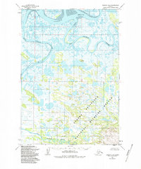
1954 Map of Ugashik B-5
USGS Topo · Published 1968About this map
Ugashik Bay and the interconnected drainage systems of the Alaska Peninsula dominate this 1954 landscape, where the tides of the Bering Sea meet a complex network of tundra waterways. The winding course of the Ugashik River flows through the northern reaches, while the King Salmon River and Dog Salmon River meander through an expanse of marshland and small lakes. Human presence is sparse, marked only by the small settlement at Dennis and an isolated Cabin to the west. This survey, mapped by the Army Map Service using 1953 aerial photography, captures the region's hydrography before significant modern development, showing unsurveyed land lines predetermined by the Bureau of Land Management along the Seward Meridian.
Find a feature on this map
6 named features on this map. Tap any name to fly to it.
Don’t see what you’re looking for? This feature index may not catch every label — zoom into the map to look around manually.
Map Details
Editions of this 1954 Ugashik B-5 Map
2 editions found
Other maps of this area

1943 · Ugashik
USGS Topo · 1:250,000

1948 · Ugashik
USGS Topo · 1:250,000

1949 · Ugashik
USGS Topo · 1:250,000

1951 · Ugashik C-5
USGS Topo · 1:63,360

1951 · Ugashik C-4
USGS Topo · 1:63,360

1951 · Ugashik C-6
USGS Topo · 1:63,360

1954 · Ugashik B-4
USGS Topo · 1:63,360

1963 · Ugashik B-6
USGS Topo · 1:63,360

1963 · Ugashik A-6
USGS Topo · 1:63,360

1963 · Ugashik A-4
USGS Topo · 1:63,360