1950s Maps of Kaktovik, Alaska
Explore 3 historic maps of Kaktovik from the 1950s. These maps offer a rare glimpse into what life looked like during the 1950s — showing old roads, neighborhoods, homes, and landmarks that have changed or disappeared over time.
Whether you're researching your family's past, planning a metal detecting trip, or studying how Kaktovik's landscape evolved across the 1950s, these high-resolution maps are a powerful tool for exploring the history of this region.
- Focus on a specific era: All maps on this page are from the 1950s, giving you a focused view of this time period.
- See what’s changed: Compare century-old streets, trails, and buildings to today's modern landscape using overlays and satellite layers.
- Research with precision: Use these maps for genealogy, historical research, land use analysis, or educational projects.
- View, download, or print: Maps are fully viewable online in high resolution, and can be downloaded or printed for your own records.
Start exploring Kaktovik's history through authentic maps from the 1950s. This is your window into the past.
Kaktovik, AK maps
(3)- 1951 Map of Barter Island
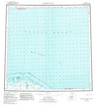
 1951 Barter Island1951 Print · USGSThe Arctic coastline of Alaska's North Slope appears in the early 1950s as a stretch of barrier islands and isolated river deltas. Trace early coastal outposts and maritime landmarks like Teddy Bear Hbr, Arey Island, and the mouth of the Jago River.
 - 1955 Map of Barter Island A-5, 1969 Print
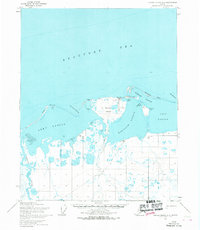 1955 Barter Island A-51969 Print · USGSThe Beaufort Sea coast of Alaska is captured here in the mid-1950s, detailing the strategic and natural geography of the North Slope. Researchers can trace the layout of Kaktovik, the nearby Landing Strip, and the historic Elupak (Site).3 unique versions available
 - 1959 Map of Barter Island
 1959 Barter Island1959 Print · USGSThe North Slope coast during the late fifties and early sixties shows a landscape of remote settlements and vital arctic waterways. Genealogists and historians can locate the village of Kaktovik, the Elupak (Site) landmark, and coastal features like Bernard Harbor.7 unique versions available
End of results
Showing maps 1-3 of 3
Frequently asked questions
- What are the different types of historical maps available for Kaktovik?
- What is the oldest map of Kaktovik?
- Where can I purchase historical maps of Kaktovik for my home or office?
- Where can I download high-res historical maps of Kaktovik?
- Are there historical topographic maps available for Kaktovik?
- Is there historical aerial imagery available for Kaktovik?
- Where are historical maps of Kaktovik sourced from?