Old Maps of Kaktovik, Alaska for Hiking & Exploration
Hike through history with 8 historic maps of Kaktovik. Explore old trails, ghost towns, and forgotten backroads — perfect for outdoor adventurers and local explorers.
- Rediscover forgotten places: Map out old mining camps, roads, and footpaths that no longer exist on modern maps.
- Layer with modern tools: Combine with LiDAR or satellite views to plan hikes through historical terrain.
- Made for exploration: Popular among hikers, overlanders, and local history lovers.
Use these maps to find adventure and explore the hidden past of Kaktovik.
Kaktovik, AK maps
(8)- 1951 Map of Barter Island
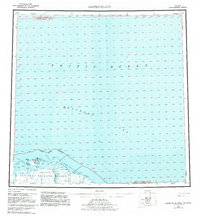
 1951 Barter Island1951 Print · USGSThe Arctic coastline of Alaska's North Slope appears in the early 1950s as a stretch of barrier islands and isolated river deltas. Trace early coastal outposts and maritime landmarks like Teddy Bear Hbr, Arey Island, and the mouth of the Jago River.
 - 1955 Map of Barter Island A-5, 1969 Print
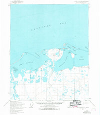 1955 Barter Island A-51969 Print · USGSThe Beaufort Sea coast of Alaska is captured here in the mid-1950s, detailing the strategic and natural geography of the North Slope. Researchers can trace the layout of Kaktovik, the nearby Landing Strip, and the historic Elupak (Site).3 unique versions available
 - 1959 Map of Barter Island
 1959 Barter Island1959 Print · USGSThe North Slope coast during the late fifties and early sixties shows a landscape of remote settlements and vital arctic waterways. Genealogists and historians can locate the village of Kaktovik, the Elupak (Site) landmark, and coastal features like Bernard Harbor.7 unique versions available
 - 1964 Map of Barter Island
 1964 Barter Island1964 Print · USGSThe Beaufort Sea coastline and the settlement of Barter Island are captured here in the mid-sixties. Researchers can trace the location of Kaktovik, the Landing Field, and the Tractor trails that connected remote Cabins along the Jago River.
 - 2018 Map of Barter Island A-5 NE, 2018 Print
 2018 Barter Island A-5 NE2018 Print · USGSCovers Kaktovik, including North Slope, United States, and other nearby areas
 - 2018 Map of Barter Island A-5 SE, 2018 Print
 2018 Barter Island A-5 SE2018 Print · USGSCovers Kaktovik, including North Slope, United States, and other nearby areas
 - 2024 Map of Barter Island A-5 NE, 2024 Print
 2024 Barter Island A-5 NE2024 Print · USGSThe Arctic coast near the Beaufort Sea is documented here in the early twenty-first century, showing the intersection of protected wilderness and local infrastructure. Researchers can trace coastal landforms like Bernard Spit and small-scale roads such as Airport Road and Pipsuk Street.
 - 2024 Map of Barter Island A-5 SE, 2024 Print
 2024 Barter Island A-5 SE2024 Print · USGSCoastal North Slope life is documented here in the early twenty-first century, centering on the remote community of Kaktovik. Researchers can trace local infrastructure from Barter Island Airport to the shores of Kaktovik Lagoon.
End of results
Showing maps 1-8 of 8
Frequently asked questions
- What are the different types of historical maps available for Kaktovik?
- What is the oldest map of Kaktovik?
- Where can I purchase historical maps of Kaktovik for my home or office?
- Where can I download high-res historical maps of Kaktovik?
- Are there historical topographic maps available for Kaktovik?
- Is there historical aerial imagery available for Kaktovik?
- Where are historical maps of Kaktovik sourced from?