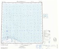
1964 Map of Barter Island
USGS Topo · Published 1964About this map
Barter Island serves as the primary focal point of this 1964 Arctic coastal survey, documenting the settlement of Kaktovik alongside a noted Kaktovik (Site) and a Landing Field. The map detail captures the intricate geography of the Beaufort Sea coastline, where a series of barrier features such as Bernard Spit and Jago Spit protect a network of lagoons including Arey Lagoon and Jago Lagoon.
Find a feature on this map
27 named features on this map. Tap any name to fly to it.
Don’t see what you’re looking for? This feature index may not catch every label — zoom into the map to look around manually.
Map Details
Editions of this 1964 Barter Island Map
This is the sole edition of this map. No revisions or reprints were ever made.
Other maps of this area

1951 · Barter Island
USGS Topo · 1:250,000

1951 · Demarcation Point
USGS Topo · 1:250,000

1951 · Mt. Michelson
USGS Topo · 1:250,000

1955 · Flaxman Island
USGS Topo · 1:250,000

1955 · Demarcation Point
USGS Topo · 1:250,000

1955 · Flaxman Island A-1
USGS Topo · 1:63,360

1955 · Demarcation Point D-3
USGS Topo · 1:63,360

1955 · Barter Island A-5
USGS Topo · 1:63,360

1955 · Demarcation Point D-2
USGS Topo · 1:63,360

1955 · Barter Island A-4
USGS Topo · 1:63,360