
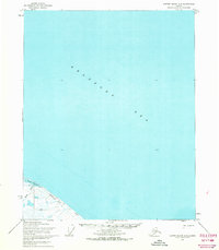
1955 Map of Demarcation Point D-3
USGS Topo · Published 1967About this map
The Arctic National Wildlife Range spans the southern portion of this mid-century survey, illustrating the raw coastal interface of the Beaufort Sea. Along the North Slope, the landscape is defined by a series of shallow lagoons and protective spits, notably Angun Lagoon and Nuvagapak Lagoon. Human activity in this remote territory is sparse but evident through specific infrastructure such as the Tractor Trail leading toward a landing strip and tower at Nuvagapak Point. This area represents the critical transition between the tundra and the sea, where multiple braided waterways like the Aichilik River and Kogotpak River discharge into the coastal waters. The presence of Ruins and a cabin near Angun Point provides a glimpse into the seasonal or early habitation patterns of the region before more modern infrastructure reached this part of the Alaskan coast.
Find a feature on this map
20 named features on this map. Tap any name to fly to it.
Don’t see what you’re looking for? This feature index may not catch every label — zoom into the map to look around manually.
Map Details
Editions of this 1955 Demarcation Point D-3 Map
This is the sole edition of this map. No revisions or reprints were ever made.
Other maps of this area

1951 · Barter Island
USGS Topo · 1:250,000

1951 · Demarcation Point
USGS Topo · 1:250,000

1955 · Demarcation Point
USGS Topo · 1:250,000

1955 · Demarcation Point C-4
USGS Topo · 1:63,360

1955 · Demarcation Point D-2
USGS Topo · 1:63,360

1955 · Barter Island A-4
USGS Topo · 1:63,360
1955 · Barter Island A-3
USGS Topo · 1:63,360

1955 · Demarcation Point C-2
USGS Topo · 1:63,360

1955 · Demarcation Point D-4
USGS Topo · 1:63,360

1955 · Demarcation Point C-3
USGS Topo · 1:63,360