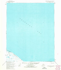
1955 Map of Barter Island A-3
USGS Topo · Published 1969About this map
The Beaufort Sea dominates the northern landscape of this arctic survey, where the frozen coastline meets the waters of the North Slope. Along the shore, the Pokok Lagoon is fed by Pokok Creek, creating a complex maritime environment within the Arctic National Wildlife Range. The presence of Health Cabins and several Ruins suggests a history of seasonal human activity or subsistence living in this challenging climate. Movement through this landscape during the mid-1950s was facilitated by a network of Tractor Trails that hug the coast, providing vital connections between landmarks like David. This map captures a specific moment when terrestrial surveying met photogrammetric methods to document the unsurveyed and unmarked locations of the Umiat Meridian.
Find a feature on this map
8 named features on this map. Tap any name to fly to it.
Don’t see what you’re looking for? This feature index may not catch every label — zoom into the map to look around manually.
Map Details
Editions of this 1955 Barter Island A-3 Map
2 editions found
Other maps of this area

1951 · Barter Island
USGS Topo · 1:250,000

1951 · Demarcation Point
USGS Topo · 1:250,000

1955 · Demarcation Point
USGS Topo · 1:250,000

1955 · Demarcation Point D-3
USGS Topo · 1:63,360

1955 · Demarcation Point D-2
USGS Topo · 1:63,360

1955 · Barter Island A-4
USGS Topo · 1:63,360

1955 · Demarcation Point D-4
USGS Topo · 1:63,360

1959 · Barter Island
USGS Topo · 1:250,000

1962 · Demarcation Point D-3
USGS Topo · 1:50,000

1964 · Demarcation Point
USGS Topo · 1:250,000