
1955 Map of Demarcation Point D-2
USGS Topo · Published 1969About this map
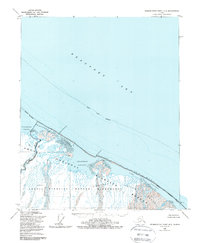
The Beaufort Sea coastline of northern Alaska, as it appeared during the mid-1950s, is defined here by a complex system of barrier islands and shallow lagoons. This maritime landscape within the Arctic National Wildlife Range shows a delicate shoreline where the Siku Reef separates the open sea from protected waters like Icy Lagoon and Egaksrak Lagoon. The map illustrates the hydrological patterns of several major watercourses, including the Kongakut River and its expansive Delta, alongside the Aichteilik River and Egaksrak River. These rivers deposit sediment into the lagoons, creating a shifting environment accessible only through narrow openings like Siku Entrance and Egaksrak Entrance. This 1955 survey provides an essential look at the undeveloped coastal geography of the North Slope before significant modern shifts in the Arctic environment.
Find a feature on this map
14 named features on this map. Tap any name to fly to it.
Don’t see what you’re looking for? This feature index may not catch every label — zoom into the map to look around manually.
Map Details
Editions of this 1955 Demarcation Point D-2 Map
2 editions found
Other maps of this area

1951 · Barter Island
USGS Topo · 1:250,000

1951 · Demarcation Point
USGS Topo · 1:250,000

1955 · Demarcation Point
USGS Topo · 1:250,000

1955 · Demarcation Point D-3
USGS Topo · 1:63,360
1955 · Demarcation Point C-1
USGS Topo · 1:63,360
1955 · Barter Island A-3
USGS Topo · 1:63,360

1955 · Demarcation Point C-2
USGS Topo · 1:63,360

1955 · Demarcation Point C-3
USGS Topo · 1:63,360

1959 · Barter Island
USGS Topo · 1:250,000

1962 · Demarcation Point D-3
USGS Topo · 1:50,000