
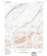
1955 Map of Demarcation Point C-3
USGS Topo · Published 1970About this map
The Arctic National Wildlife Range defines the vast landscape of this 1955 survey, capturing a remote section of the North Slope where the land meets the Beaufort Sea. The terrain is dominated by a complex braided water system, with the Aichilik River and Kogotpak River cutting across the northern reaches toward the coast. Further south, the map reveals the transition from coastal plains to the rising elevations of the interior, where the Egaksrak River and Ekaluakat River carve their paths through the mountains. Mapped by the Army Map Service using aerial photography, the sheet reflects an era of intensive northern surveying where land lines were predetermined by the Bureau of Land Management but remained largely unsurveyed on the ground. The lack of named human settlements emphasizes the character of the region as a preserved wilderness at the time of the map's creation.
Find a feature on this map
5 named features on this map. Tap any name to fly to it.
Don’t see what you’re looking for? This feature index may not catch every label — zoom into the map to look around manually.
Map Details
Editions of this 1955 Demarcation Point C-3 Map
2 editions found
Other maps of this area

1951 · Demarcation Point
USGS Topo · 1:250,000

1955 · Demarcation Point
USGS Topo · 1:250,000

1955 · Demarcation Point D-3
USGS Topo · 1:63,360

1955 · Demarcation Point C-4
USGS Topo · 1:63,360

1955 · Demarcation Point D-2
USGS Topo · 1:63,360

1955 · Demarcation Point C-2
USGS Topo · 1:63,360

1955 · Demarcation Point D-4
USGS Topo · 1:63,360
1956 · Demarcation Point B-4
USGS Topo · 1:63,360
1956 · Demarcation Point B-3
USGS Topo · 1:63,360

1956 · Demarcation Point B-2
USGS Topo · 1:63,360