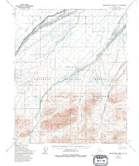
1955 Map of Demarcation Point C-3
USGS Topo · Published 1994About this map
The Aichilik River meanders across this northern landscape, marking a transition from the coastal plains into the foothills of the Brooks Range. Captured through aerial photography in 1955, the terrain reveals a complex network of braided waterways and glacial drainages. The Egaksrak River and Ekaluakat River carve prominent paths through the eastern half of the sheet, illustrating the natural drainage patterns of the Arctic National Wildlife Refuge. This map is particularly significant for its representation of federal land boundaries, including the Arctic Wildlife Refuge Wilderness and the Aichilik River Wilderness, which were later formalized by the Alaska National Interest Lands Conservation Act. The lack of roads or established trails highlights the enduring character of this unpopulated region, where topographical features like Redwacke Creek serve as the primary landmarks for navigation.
Find a feature on this map
7 named features on this map. Tap any name to fly to it.
Don’t see what you’re looking for? This feature index may not catch every label — zoom into the map to look around manually.
Map Details
Editions of this 1955 Demarcation Point C-3 Map
2 editions found
Other maps of this area

1951 · Demarcation Point
USGS Topo · 1:250,000

1955 · Demarcation Point
USGS Topo · 1:250,000

1955 · Demarcation Point D-3
USGS Topo · 1:63,360

1955 · Demarcation Point C-4
USGS Topo · 1:63,360

1955 · Demarcation Point D-2
USGS Topo · 1:63,360

1955 · Demarcation Point C-2
USGS Topo · 1:63,360

1955 · Demarcation Point D-4
USGS Topo · 1:63,360

1955 · Demarcation Point C-3
USGS Topo · 1:63,360
1956 · Demarcation Point B-4
USGS Topo · 1:63,360
1956 · Demarcation Point B-3
USGS Topo · 1:63,360