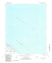
1955 Map of Barter Island A-3
USGS Topo · Published 1985About this map
The Beaufort Sea dominates this mid-century survey, meeting the coastal tundra along the northern edge of the North Slope Borough. The landscape is characterized by the complex interaction of land and water at Pokok Lagoon, where Pokok Creek drains into the arctic waters. This coastal zone is part of the Arctic National Wildlife Refuge, preserving a remote environment where human presence is marked only by sparse Cabins and a network of Winter Trails. These trails provide a rare glimpse into the seasonal transport patterns of the era, long before modern permanent infrastructure. The map represents a detailed study of the shoreline as it existed in 1955, capturing the intricate hydrography of the Alaskan arctic coast prior to significant later developments.
Find a feature on this map
7 named features on this map. Tap any name to fly to it.
Don’t see what you’re looking for? This feature index may not catch every label — zoom into the map to look around manually.
Map Details
Editions of this 1955 Barter Island A-3 Map
2 editions found
Other maps of this area

1951 · Barter Island
USGS Topo · 1:250,000

1951 · Demarcation Point
USGS Topo · 1:250,000

1955 · Demarcation Point
USGS Topo · 1:250,000

1955 · Demarcation Point D-3
USGS Topo · 1:63,360

1955 · Demarcation Point D-2
USGS Topo · 1:63,360

1955 · Barter Island A-4
USGS Topo · 1:63,360
1955 · Barter Island A-3
USGS Topo · 1:63,360

1955 · Demarcation Point D-4
USGS Topo · 1:63,360

1959 · Barter Island
USGS Topo · 1:250,000

1962 · Demarcation Point D-3
USGS Topo · 1:50,000