Old Maps of Kaktovik, Alaska for Academic Research
Study the evolution of Kaktovik with 8 high-resolution historic maps. Whether you're teaching, researching, or modeling changes in land use, these maps provide essential visual documentation of urban, environmental, and geographic change.
- Analyze long-term change: Track patterns in development, transportation, and natural features.
- Ideal for environmental or urban studies: Support academic projects with primary historical map data.
- Use in the classroom or lab: Educators and researchers rely on these maps to bring historical context to life.
These maps are a powerful tool for teaching, research, and visualizing how Kaktovik has changed over the decades.
Kaktovik, AK maps
(8)- 1951 Map of Barter Island
 1951 Barter Island1951 Print · USGSThe Arctic coastline of Alaska's North Slope appears in the early 1950s as a stretch of barrier islands and isolated river deltas. Trace early coastal outposts and maritime landmarks like Teddy Bear Hbr, Arey Island, and the mouth of the Jago River.
 - 1955 Map of Barter Island A-5, 1969 Print
 1955 Barter Island A-51969 Print · USGSThe Beaufort Sea coast of Alaska is captured here in the mid-1950s, detailing the strategic and natural geography of the North Slope. Researchers can trace the layout of Kaktovik, the nearby Landing Strip, and the historic Elupak (Site).3 unique versions available
 - 1959 Map of Barter Island
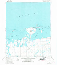
 1959 Barter Island1959 Print · USGSThe North Slope coast during the late fifties and early sixties shows a landscape of remote settlements and vital arctic waterways. Genealogists and historians can locate the village of Kaktovik, the Elupak (Site) landmark, and coastal features like Bernard Harbor.7 unique versions available
 - 1964 Map of Barter Island
 1964 Barter Island1964 Print · USGSThe Beaufort Sea coastline and the settlement of Barter Island are captured here in the mid-sixties. Researchers can trace the location of Kaktovik, the Landing Field, and the Tractor trails that connected remote Cabins along the Jago River.
 - 2018 Map of Barter Island A-5 NE, 2018 Print
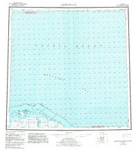
 2018 Barter Island A-5 NE2018 Print · USGSCovers Kaktovik, including North Slope, United States, and other nearby areas
 - 2018 Map of Barter Island A-5 SE, 2018 Print
 2018 Barter Island A-5 SE2018 Print · USGSCovers Kaktovik, including North Slope, United States, and other nearby areas
 - 2024 Map of Barter Island A-5 NE, 2024 Print
 2024 Barter Island A-5 NE2024 Print · USGSThe Arctic coast near the Beaufort Sea is documented here in the early twenty-first century, showing the intersection of protected wilderness and local infrastructure. Researchers can trace coastal landforms like Bernard Spit and small-scale roads such as Airport Road and Pipsuk Street.
 - 2024 Map of Barter Island A-5 SE, 2024 Print
 2024 Barter Island A-5 SE2024 Print · USGSCoastal North Slope life is documented here in the early twenty-first century, centering on the remote community of Kaktovik. Researchers can trace local infrastructure from Barter Island Airport to the shores of Kaktovik Lagoon.
End of results
Showing maps 1-8 of 8
Frequently asked questions
- What are the different types of historical maps available for Kaktovik?
- What is the oldest map of Kaktovik?
- Where can I purchase historical maps of Kaktovik for my home or office?
- Where can I download high-res historical maps of Kaktovik?
- Are there historical topographic maps available for Kaktovik?
- Is there historical aerial imagery available for Kaktovik?
- Where are historical maps of Kaktovik sourced from?