Old Maps of Kukpuk, Alaska for Hiking & Exploration
Hike through history with 5 historic maps of Kukpuk. Explore old trails, ghost towns, and forgotten backroads — perfect for outdoor adventurers and local explorers.
- Rediscover forgotten places: Map out old mining camps, roads, and footpaths that no longer exist on modern maps.
- Layer with modern tools: Combine with LiDAR or satellite views to plan hikes through historical terrain.
- Made for exploration: Popular among hikers, overlanders, and local history lovers.
Use these maps to find adventure and explore the hidden past of Kukpuk.
Kukpuk, AK maps
(5)- 1952 Map of Point Hope, 1953 Print
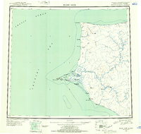 1952 Point Hope1953 Print · USGSCoastal Alaska at the mid-century shows a sparse but vital network of Arctic settlements and resource extraction points. Researchers can trace the Winter Trail past Wevok to the Corwin Mine or locate the Cem near the Point Hope village.
 - 1955 Map of Point Hope, 1964 Print
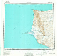 1955 Point Hope1964 Print · USGSCoastal Alaska at the edge of the Arctic comes into focus in this mid-century survey of the Chukchi Sea coastline. Genealogists and researchers can trace the locations of Point Hope, the Jabbertown site, and the remote Corwin Mine and Chariot settlements.3 unique versions available
 - 1955 Map of Point Hope B-2, 1966 Print
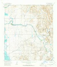 1955 Point Hope B-21966 Print · USGSThe North Slope coastline meets the Lisburne Hills in the mid-1950s, showing a remote landscape shaped by the Kukpuk River. Genealogists and researchers can locate early settlements and sites like Kukpuk, Itublurak, and the Kayak (site).2 unique versions available
 - 1965 Map of Point Hope
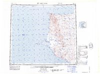 1965 Point Hope1965 Print · USGSCoastal North Slope Alaska is captured in the mid-1960s, showing the intersection of remote settlements and military-era infrastructure. Genealogists and historians can trace the Winter Trail, the remains of Jabbertown, and numerous historical sites like Kukpuk.
 - 2014 Map of Point Hope B-2 NW, 2014 Print
 2014 Point Hope B-2 NW2014 Print · USGSThe North Slope landscape is captured here in the early twenty-first century, featuring the broad winding path of the Kukpuk River. Researchers can trace the complex drainage patterns of the Arctic tundra through local waterways like Tusikpak Lake and Taktelak Cr.
End of results
Showing maps 1-5 of 5
Frequently asked questions
- What are the different types of historical maps available for Kukpuk?
- What is the oldest map of Kukpuk?
- Where can I purchase historical maps of Kukpuk for my home or office?
- Where can I download high-res historical maps of Kukpuk?
- Are there historical topographic maps available for Kukpuk?
- Is there historical aerial imagery available for Kukpuk?
- Where are historical maps of Kukpuk sourced from?