1960s Maps of Sitka, Alaska
Explore 3 historic maps of Sitka from the 1960s. These maps offer a rare glimpse into what life looked like during the 1960s — showing old roads, neighborhoods, homes, and landmarks that have changed or disappeared over time.
Whether you're researching your family's past, planning a metal detecting trip, or studying how Sitka's landscape evolved across the 1960s, these high-resolution maps are a powerful tool for exploring the history of this region.
- Focus on a specific era: All maps on this page are from the 1960s, giving you a focused view of this time period.
- See what’s changed: Compare century-old streets, trails, and buildings to today's modern landscape using overlays and satellite layers.
- Research with precision: Use these maps for genealogy, historical research, land use analysis, or educational projects.
- View, download, or print: Maps are fully viewable online in high resolution, and can be downloaded or printed for your own records.
Start exploring Sitka's history through authentic maps from the 1960s. This is your window into the past.
Sitka, AK maps
(3)- 1962 Map of Juneau, 1966 Print
 1962 Juneau1966 Print · USGSSoutheast Alaska in the early sixties showcases a maritime landscape defined by the Tongass National Forest and the peaks of the Coast Mountains. Trace the footprints of coastal industry at Treadwell, Thane, and the regional hub of Juneau.7 unique versions available
 - 1964 Map of Sitka
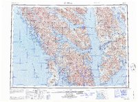 1964 Sitka1964 Print · USGSSoutheast Alaska's rugged archipelago is captured in the mid-twentieth century as maritime commerce and coastal outposts shaped the region. Genealogists and historians can trace established settlements like Sitka and Angoon or vanished points such as Gypsum and Manleyville.
 - 1964 Map of Port Alexander
 1964 Port Alexander1964 Print · USGSSoutheast Alaska in the mid-1960s was a landscape of remote coastal outposts and cannery towns connected by the sea. Trace the maritime history of the Alexander Archipelago through sites like Goddard, the Pillar Bay Cannery, and the isolated Lighthouse at Cape Decision.
End of results
Showing maps 1-3 of 3
Top cities of Sitka
Frequently asked questions
- What are the different types of historical maps available for Sitka?
- What is the oldest map of Sitka?
- Where can I purchase historical maps of Sitka for my home or office?
- Where can I download high-res historical maps of Sitka?
- Are there historical topographic maps available for Sitka?
- Is there historical aerial imagery available for Sitka?
- Where are historical maps of Sitka sourced from?