Old Maps of Sitka, Alaska for Genealogy
Trace your family roots with 285 historic maps of Sitka. These high-res maps reveal old neighborhoods, homesites, landmarks, and streets — helping you uncover where your ancestors lived and how the area evolved over time.
- Explore historic neighborhoods: Identify where your relatives may have lived in the 1800s or 1900s.
- Compare maps over time: Trace the changes in streets, buildings, and landmarks for multi-generational research.
- Perfect for genealogy & ancestry research: Used by family historians and researchers to map out lineage and migration.
These maps are an incredible resource for exploring your personal connection to Sitka's past.
Sitka, AK maps
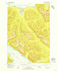
(285)- 1948 Map of Sitka B-3, 1956 Print
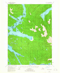
 1948 Sitka B-31956 Print · USGSThe Alexander Archipelago in the late 1940s reveals a complex network of glacial fjords and forested islands before modern development. Trace the maritime landscape through Kelp Bay to find isolated Cabins and named landmarks like Pond Island.
 - 1948 Map of Sitka A-5, 1956 Print
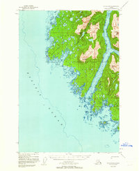
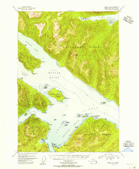
 1948 Sitka A-51956 Print · USGSSitka and its surrounding islands appear here in the late 1940s, highlighting a landscape shaped by military activity and deep coastal history. Researchers can trace the Naval Res, find the Old Sitka (Ruins), and locate the Indian Vil.
 - 1948 Map of Sitka A-3, 1956 Print
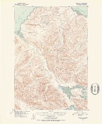
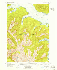
 1948 Sitka A-31956 Print · USGSThe eastern shore of Baranof Island comes into focus in the late 1940s, highlighting remote settlements and maritime landmarks. Researchers can locate the settlement of Manleyville, the Sawmill (Aband) at Kasnyku Bay, and natural features like the Hot Spring near Baranof Lake.
 - 1948 Map of Sitka C-7, 1956 Print
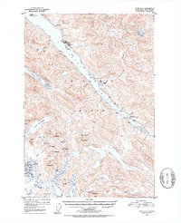
 1948 Sitka C-71956 Print · USGSCoastal Chichagof Island appears here in the late 1940s, highlighting the isolated settlements and complex waterways of Southeast Alaska. Maritime researchers can trace the routes through Ogden Passage and locate the historic sites at Kimshan Cove and Klag.
 - 1948 Map of Sitka C-3, 1956 Print
 1948 Sitka C-31956 Print · USGSCoastal wilderness in the Alexander Archipelago is charted during the late 1940s, mapping the maritime divide of Chatham Strait. Trace the natural shoreline from Marble Bluffs on Admiralty Island across to the inlets of Basket Bay and Sitkoh Bay.
 - 1948 Map of Sitka D-5, 1956 Print
 1948 Sitka D-51956 Print · USGSChichagof Island in the late 1940s is defined by its deep waterways and the vast Tongass National Forest. Local history researchers can trace the shoreline from The Narrows to Tenakee Inlet, locating isolated landmarks like a solitary Cabin and Saltery Bay.
 - 1948 Map of Sitka D-3, 1956 Print
 1948 Sitka D-31956 Print · USGSChatham Strait separates the rugged coasts of Chichagof and Admiralty Islands in the late 1940s. Genealogists and researchers can locate evidence of former industry at Gypsum (Aband) or trace the remote Cabin sites and trails near Lake Florence and Cube Cove.
 - 1948 Map of Sitka D-4, 1957 Print
 1948 Sitka D-41957 Print · USGSChichagof Island in the late 1940s reveals a landscape of isolated cabins and maritime hubs within the national forest. Trace early settlement at Tenakee, locate the coastal Cem, or explore the waters of Freshwater Bay.
 - 1948 Map of Sitka C-6, 1957 Print
 1948 Sitka C-61957 Print · USGSChichagof Island in the late 1940s remains a maritime wilderness of deep fjords and coastal peaks. Trace early activity through the Powerhouse on the southern coast or the remote Cabins tucked away at Fick Cove.
 - 1948 Map of Sitka D-6, 1957 Print
 1948 Sitka D-61957 Print · USGSChichagof Island in the late 1940s is shown here as a wilderness of deep fjords and high timber within the Tongass National Forest. Researchers can trace early coastal geography at the Portage isthmus and along the shores of Tenakee Inlet and Salt Lake Bay.
 - 1948 Map of Port Alexander A-2, 1958 Print
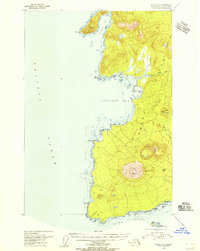
 1948 Port Alexander A-21958 Print · USGSThe southern tip of Baranof Island and the isolated outpost of Port Alexander are captured here in the late forties. Maritime historians and genealogists can trace the waterfront settlement, the local Cem, and landmarks like Cape Ommaney.
 - 1948 Map of Port Alexander A-3, 1958 Print
 1948 Port Alexander A-31958 Print · USGSBaranof Island's southernmost reaches are documented here in the late 1940s, showing a maritime landscape shaped by the Pacific. Researchers can trace the rugged coastline from the heights of Ommaney Peak to the waters of Port Conclusion.
 - 1948 Map of Port Alexander B-2, 1958 Print
 1948 Port Alexander B-21958 Print · USGSBaranof Island and the waters of Chatham Strait are captured in the late 1940s, showing the remote maritime outposts of Southeast Alaska. Trace the coastal developments at Port Alexander and Port Armstrong, or find the secluded Cabin near New Port Walter.
 - 1948 Map of Sitka D-8, 1962 Print
 1948 Sitka D-81962 Print · USGSThe coastal wilderness of Southeast Alaska is documented here during the mid-century, focusing on the remote waterways of Yakobi Island. Researchers can trace early maritime outposts at White Sulphur Springs and Mindalina or explore the rugged topography of the Bohemia Basin.3 unique versions available
 - 1948 Map of Sitka B-5, 1963 Print
 1948 Sitka B-51963 Print · USGSThe maritime crossroads of Southeast Alaska are captured here just after the war, mapping the complex channels between Baranof and Chichagof Islands. Trace the remote coastline to find historic Cabins, the Highwater Cabin, and treacherous waters like Sergius Narrows.3 unique versions available
 - 1950 Map of Sitka D-8
 1950 Sitka D-81950 Print · USGSYakobi and Chichagof Islands appear in the late 1940s, revealing the intricate coastline of the Tongass National Forest before modern development. Maritime researchers and genealogists can trace early landmarks like White Sulphur Springs, Surge Bay Light, and the Bohemia Basin.2 unique versions available
 - 1951 Map of Juneau
 1951 Juneau1951 Print · USGSJuneau and the industrial waterfront of the Gastineau Channel are shown here at the start of the 1950s. Researchers can trace the mid-century footprint of Juneau, the mining history of Treadwell, and remote maritime outposts like Hoonah and Gustavus.4 unique versions available
 - 1951 Map of Juneau A-6, 1952 Print
 1951 Juneau A-61952 Print · USGSChichagof Island in the early fifties remains a wilderness of the Tongass National Forest, defined by its deep fjords and isolated shores. Researchers can locate remote outposts like Cabins at Neka Bay and a lonely Camp overlooking the Icy Strait.6 unique versions available
 - 1951 Map of Sitka D-7, 1953 Print
 1951 Sitka D-71953 Print · USGSChichagof Island in the early fifties shows a landscape of remote mines, logging outposts, and new coastal settlements. Trace the early boundaries of Pelican or locate the historic Apex Mine and El Nido Mine nestled above Lisianski Inlet.6 unique versions available
 - 1951 Map of Sitka B-4, 1956 Print
 1951 Sitka B-41956 Print · USGSThe maritime wilderness of Baranof Island and Peril Strait is captured here in the mid-1950s, highlighting the remote coastal outposts of the First Judicial Division. Researchers can locate early navigation markers like McClellan Rk Light and isolated structures such as the Shelter Cabin near Lake Eva.3 unique versions available
 - 1951 Map of Sitka C-5, 1956 Print
 1951 Sitka C-51956 Print · USGSSoutheast Alaska’s coastal wilderness comes into focus in the early fifties, centering on the maritime junction where Chichagof and Baranof Islands meet. You can trace early shoreline landings at Favorite Anchorage and identify isolated Cabins near Poison Cove.4 unique versions available
 - 1951 Map of Sitka A-6, 1956 Print
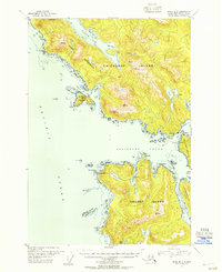
 1951 Sitka A-61956 Print · USGSKruzof Island in the early fifties remains a rugged coastal wilderness dominated by the volcanic peak of Mt Edgecumbe. Researchers can trace old footpaths to Shelter Cabin or explore the remote shoreline at Shelikof Bay and the St Lazaria Nat Wildlife Refuge.4 unique versions available
 - 1951 Map of Sitka B-6, 1956 Print
 1951 Sitka B-61956 Print · USGSSoutheast Alaska’s coastal wilderness is captured in the early fifties, documenting the intersection of the outer islands before modern development. Genealogists and maritime historians can trace isolated Cabins and remote landmarks like Lake Suloia and Mt Georgiana.4 unique versions available
 - 1951 Map of Sitka C-4, 1956 Print
 1951 Sitka C-41956 Print · USGSSoutheast Alaska at mid-century remains a landscape of maritime solitude and jagged peaks within the Tongass National Forest. Genealogists and researchers can locate remote cabins along Kadashan Bay and trace the complex shorelines of Peril Strait and Tenakee Inlet.3 unique versions available
 - 1951 Map of Sitka B-5, 1956 Print
 1951 Sitka B-51956 Print · USGSSoutheast Alaska in the early fifties shows a landscape of deep fjords and maritime isolation before modern development. Researchers can trace remote coastal life through the locations of Highwater Cabin, a Hot Spring, and navigations through Sergius Narrows.
Showing maps 1-25 of 285
Top cities of Sitka
Frequently asked questions
- What are the different types of historical maps available for Sitka?
- What is the oldest map of Sitka?
- Where can I purchase historical maps of Sitka for my home or office?
- Where can I download high-res historical maps of Sitka?
- Are there historical topographic maps available for Sitka?
- Is there historical aerial imagery available for Sitka?
- Where are historical maps of Sitka sourced from?